Hertford Castle Weir

Log in to your account

AroundUs is a community-driven map of interesting places, built by curious explorers like you. It grows with every review, story, and photo you share.
Connect to save your favorite spots, contribute locations, and create personalized routes.
By continuing, you accept our Terms and Conditions and our Privacy Policy

Hertford Castle Weir

Add to collection
Map
Suggest a change
Share

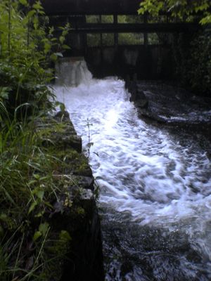
Hertford Castle Weir, River Lea weir in Hertford, England

The Hertford Castle Weir extends 65 meters across the River Lea, featuring a vertical drop of 70 centimeters onto a secondary concrete block.

The weir marks the beginning point of the River Lee Navigation, connecting the upper River Lea to sections flowing through Hertfordshire and London.

The structure stands near the Hertford Theatre, offering local residents opportunities for fishing, kayaking, and whitewater activities throughout the year.

Located off Mill Bridge in central Hertford, the weir includes three sections and a stilling pool that manages water flow under the road.

The weir pool provides specific conditions for experienced kayakers to practice advanced techniques, with varying water levels affecting navigation patterns.

GPS coordinates: 51.78704,-0.08666

Latest update: March 7, 2025 23:19

Around this place
Show the full map
Hertford Castle
United Kingdom

Hertford Castle

1 km
County Hall Including Terraces And Fountain
United Kingdom

County Hall Including Terraces And Fountain

502 m
The White Horse Public House
United Kingdom

The White Horse Public House

929 m
Willowmead
United Kingdom

Willowmead

861 m
Church of St Andrew
United Kingdom

Church of St Andrew

1.1 km
War Memorial in North Churchyard, Church of St Andrew
United Kingdom

War Memorial in North Churchyard, Church of St Andrew

1.1 km
Hornsmill Viaduct
United Kingdom

Hornsmill Viaduct

203 m
Footbridge Over River Mimram And Railings
United Kingdom

Footbridge Over River Mimram And Railings

1 km
Cecil House
United Kingdom

Cecil House

1.1 km
Castle Moat House
United Kingdom

Castle Moat House

970 m
Coachouse And Stables To Number 23
United Kingdom

Coachouse And Stables To Number 23

982 m
Forecourt To County Hall Including Bas Relief Drum, Lamp Posts, Boundary Marker
United Kingdom

Forecourt To County Hall Including Bas Relief Drum, Lamp Posts, Boundary Marker

525 m
54, St Andrew Street
United Kingdom

54, St Andrew Street

1 km
58 And 60, St Andrew Street
United Kingdom

58 And 60, St Andrew Street

1 km
Gatehouse To Hertford Castle (hertford Castle Demolished)
United Kingdom

Gatehouse To Hertford Castle (hertford Castle Demolished)

997 m
78-84, Horns Mill Road
United Kingdom

78-84, Horns Mill Road

62 m
14,16,18 And 18A, Castle Street
United Kingdom

14,16,18 And 18A, Castle Street

1.1 km
20, Castle Street
United Kingdom

20, Castle Street

1.1 km
56, St Andrew Street
United Kingdom

56, St Andrew Street

1 km
24, Castle Street
United Kingdom

24, Castle Street

1 km
Churchyard Wall To Church Of St Andrew
United Kingdom

Churchyard Wall To Church Of St Andrew

1.1 km
29, Castle Street
United Kingdom

29, Castle Street

939 m
Cawthorne
United Kingdom

Cawthorne

1 km
Boundary Railings To St Andrews Churchyard
United Kingdom

Boundary Railings To St Andrews Churchyard

1 km
The Walnuts (number 23) Including Front Railings
United Kingdom

The Walnuts (number 23) Including Front Railings

1 km
Icehouse Approximately 35 Metres South Of Postern, Hertford Castle (Hertford Castle Demolished)
United Kingdom

Icehouse Approximately 35 Metres South Of Postern, Hertford Castle (Hertford Castle Demolished)

961 m
Hertford Viaduct
United Kingdom

Hertford Viaduct

588 m
Bailey Walls, South East Range To Hertford Castle (hertford Castle Demolished)
United Kingdom

Bailey Walls, South East Range To Hertford Castle (hertford Castle Demolished)

978 m
Show the full map

Reviews

Visited this place? Tap the stars to rate it and share your experience / photos with the community! Try now! You can cancel it anytime.

« Hertford Castle Weir - River Lea weir in Hertford, England » is provided by Around Us (aroundus.com). Images and texts are derived from Wikimedia project under a Creative Commons license. You are allowed to copy, distribute, and modify copies of this page, under the conditions set by the license, as long as this note is clearly visible.

Discover hidden gems everywhere you go!

From secret cafés to breathtaking viewpoints, skip the crowded tourist spots and find places that match your style. Our app makes it easy with voice search, smart filtering, route optimization, and insider tips from travelers worldwide. Download now for the complete mobile experience.

Around Us App Screenshot

A unique approach to discovering new places

Le Figaro

All the places worth exploring

France Info

A tailor-made excursion in just a few clicks

20 Minutes