·

Enable Location

We need your location to show you interesting places around you

Discover nearby places

Find interesting locations and hidden gems around you

Precise directions

Get accurate directions and distances to places

Your location is never shared with other users. It's only used when you tap the location button.

Bagborough House

Log in to your account

Start exploring — it's free

Trusted by 62,635 travelers worldwide

Continue with Google
Continue with Apple
or

We will send you a code to connect

By continuing, you accept our Terms and Conditions and our Privacy Policy

Check your inbox

We've sent a pincode in your inbox. Please enter the code below.

Bagborough House

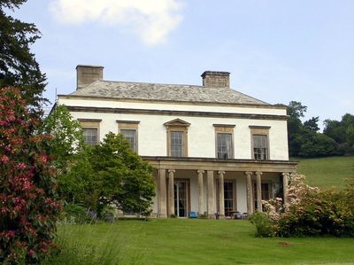
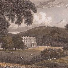
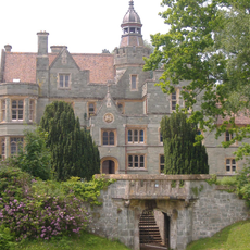
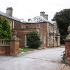
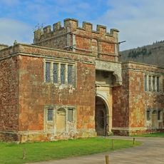
Bagborough House, Grade II* listed building in West Bagborough, England

Bagborough House is a stone residence featuring five Ionic columns on its south-facing elevation, overlooking landscaped grounds and a walled kitchen garden. The columned facade forms the main architectural focus, while the surrounding gardens are divided into formal sections.

The house was constructed in 1739 by the Popham family and underwent significant additions with a stable block in 1820 and further modifications in 1900. These expansions reflect changing needs and design preferences across generations.

The interior features decorative elements in the William Kent style from the 1730s, reflecting the design preferences of that era. Visitors can observe how these details shape the character of the rooms today.

The property functions primarily as a wedding venue managed by Diana and Philip Brooke-Popham and can be accessed by advance arrangement. Visitors should check availability before visiting, as the grounds are frequently in use for private events.

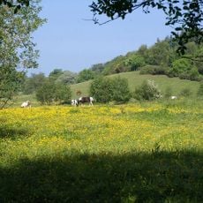
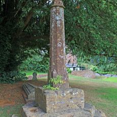
The grounds contain a registered sundial and served as a filming location for the movie Pandaemonium set in the Quantock Hills area. This film connection adds an unexpected layer to the property's history.

The community of curious travelers

AroundUs brings together thousands of curated places, local tips, and hidden gems, enriched daily by 60,000 contributors worldwide.

Start exploring
Location
GPS coordinates
51.09660,-3.18843
Latest update
December 14, 2025 18:47
Around this place
Church of St Mary, Bishops Lydeard
United Kingdom

Church of St Mary, Bishops Lydeard

4 km
Sandhill Park
United Kingdom

Sandhill Park

4 km
Cothelstone Manor
United Kingdom

Cothelstone Manor

2.3 km
Quantock Lodge
United Kingdom

Quantock Lodge

4.3 km
Church of St Peter & St Paul
United Kingdom

Church of St Peter & St Paul

3.1 km
West Bagborough Hoard
United Kingdom

West Bagborough Hoard

942 m
Plainsfield Camp
United Kingdom

Plainsfield Camp

2.9 km
Church of the Holy Ghost, Crowcombe
United Kingdom

Church of the Holy Ghost, Crowcombe

4.1 km
Church of St Thomas of Canterbury, Cothelstone
United Kingdom

Church of St Thomas of Canterbury, Cothelstone

2.2 km
Lydeard House
United Kingdom

Lydeard House

3.8 km
Church of St Pancras, West Bagborough
United Kingdom

Church of St Pancras, West Bagborough

26 m
Church of All Saints
United Kingdom

Church of All Saints

3.2 km
Roebuck Meadows
United Kingdom

Roebuck Meadows

4 km
Crowcombe War Memorial, 10 Metres South East of Church House
United Kingdom

Crowcombe War Memorial, 10 Metres South East of Church House

4.1 km
West Bagborough war memorial
United Kingdom

West Bagborough war memorial

134 m
Tower In Combe Wood At St/402 3171  Winter's Tower
United Kingdom

Tower In Combe Wood At St/402 3171 Winter's Tower

3.5 km
Triscombe House
United Kingdom

Triscombe House

2.2 km
Railway Bridge
United Kingdom

Railway Bridge

2.4 km
Footbridge Over Road At St 176 324
United Kingdom

Footbridge Over Road At St 176 324

1.4 km
Church House And Pound Adjoining To North West
United Kingdom

Church House And Pound Adjoining To North West

4.1 km
Gatehouse At Combe Florey House
United Kingdom

Gatehouse At Combe Florey House

3.1 km
Gatehouse, Cothelstone Manor
United Kingdom

Gatehouse, Cothelstone Manor

2.3 km
Cross, 3 Metres South East Of Porch, Church Of St Peter And St Paul
United Kingdom

Cross, 3 Metres South East Of Porch, Church Of St Peter And St Paul

3.1 km
Market Cross (Remains Of) In Churchyard, Church Of St Mary
United Kingdom

Market Cross (Remains Of) In Churchyard, Church Of St Mary

4 km
Milestone At St 183 316
United Kingdom

Milestone At St 183 316

2.4 km
Milestone At Ngr St 2016 3284
United Kingdom

Milestone At Ngr St 2016 3284

3.4 km
Churchyard cross immediately south of Holy Ghost Church
United Kingdom

Churchyard cross immediately south of Holy Ghost Church

4.1 km
Crowcombe village cross
United Kingdom

Crowcombe village cross

4.3 km
Show the full map
« Bagborough House - Grade II* listed building in West Bagborough, England » is provided by Around Us (aroundus.com). Images and texts are derived from Wikimedia project under a Creative Commons license. You are allowed to copy, distribute, and modify copies of this page, under the conditions set by the license, as long as this note is clearly visible.

Discover hidden gems everywhere you go!

From secret cafés to breathtaking viewpoints, skip the crowded tourist spots and find places that match your style. Our app makes it easy with voice search, smart filtering, route optimization, and insider tips from travelers worldwide. Download now for the complete mobile experience.

Around Us App Screenshot

A unique approach to discovering new places

Le Figaro

All the places worth exploring

France Info

A tailor-made excursion in just a few clicks

20 Minutes

Around Us
Travel Guide & Maps
Download

Send to your phone

QR Code
1

Open the camera app on your mobile.

2

Point at the QR code with your camera. A notification will appear.

3

Tap the notification to open the link.