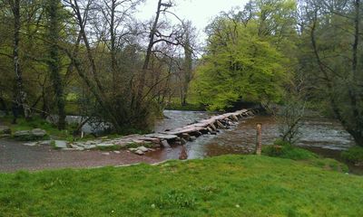
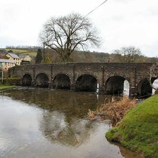
Tarr Steps, Grade I listed clapper bridge in Somerset, England, UK
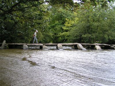
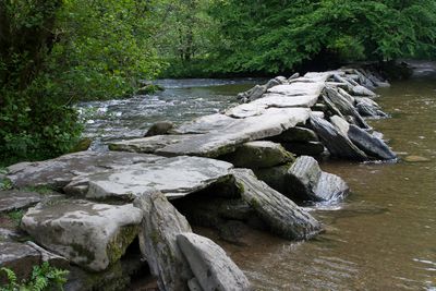
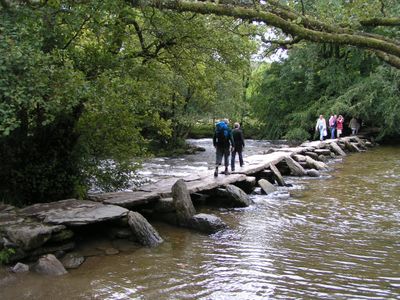
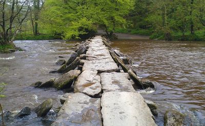
Tarr Steps is a granite stone bridge in Withypool and Hawkridge near Dulverton, England, crossing the River Barle. The bridge consists of 17 large flat stone slabs laid end to end on stone posts in the water, stretching about 55 meters in length.
The exact age is uncertain, with some scholars dating the bridge to around 1000 BCE in the Bronze Age, others to medieval times around 1400 CE. Floods have washed away the stones several times, but the marked slabs have been carefully returned to their original positions each time.
The name may come from an old Celtic word for causeway, showing how long people have used this crossing. Legends tell that the Devil built the bridge to sunbathe on the stones, cursing anyone who crossed while he was resting there.
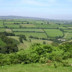
The stones are wide enough to walk on but can be slippery when wet, so take care. A parking area with toilets is nearby, and from there a path leads past the local inn down to the bridge.
Each stone slab has been numbered and marked so workers can return them correctly after floods. Some of these stones weigh about two tons, showing the effort needed to recover and reposition them after each storm.
Location: Withypool and Hawkridge
Location: Dulverton
Length: 55 m
Made from material: granite
GPS coordinates: 51.07715,-3.61766
Latest update: December 5, 2025 10:42
Devon combines historical sites and natural landscapes across a region in southwest England. The area extends from moorlands in Dartmoor National Park to cliffs along the Bristol Channel and English Channel coasts. Visitors find Norman castle ruins like Totnes Castle and Okehampton Castle, Georgian manor houses such as Saltram House, medieval villages, and monastery sites like Buckland Abbey. The landscape appears in forms of granite formations, waterfalls, remote beaches, and ancient woodlands. Places include Wistman's Wood with its gnarled oak trees, the rock formations at Valley of the Rocks near Lynton, the historic fishing village of Clovelly with its steep streets, and the sandy beaches at Bantham and Mothercombe. Speke's Mill Mouth Waterfall drops directly into the sea, while Blackchurch Rock stands as a coastal formation. Gardens like RHS Garden Rosemoor display botanical collections, and industrial sites such as the water-powered Finch Foundry or the Dartmouth Steam Railway document past working environments. Beer Quarry Caves offer views into historic underground stone quarrying.
Somerset preserves a broad range of historical sites away from the main visitor routes. The region shows medieval abbeys such as Muchelney and Cleeve, Norman castles like Stogursey and Nunney, Elizabethan manor houses including Cothay Manor and Lytes Cary, and prehistoric stone bridges such as Tarr Steps. The landscape ranges from limestone gorges like Ebbor Gorge to ancient oak woodlands and coastal sections with geological formations at Kilve Beach. The villages contain market halls, dovecotes and small churches that reflect centuries of local use.
Stone circle on Withypool Hill 670m ESE of Portford Bridge
3.7 km
Caratacus Stone
2.6 km
Ashwick House
2.6 km
Withypool Bridge
4 km
Mounsey Castle
3.2 km
South Exmoor SSSI
2.2 km
Brewer's Castle
2.8 km
Tarr Steps
2 m
Church of St Andrew
4.1 km
Church of St Giles
1.6 km
Round barrow cemetery incorporating Wambarrows on Winsford Hill
2.3 km
Withycombe Cottage
3.5 km
Bowl barrow and round cairn on Withypool Hill, 850m and 820m east of Portford Bridge
3.6 km
West Nethercote Farmhouse
4.1 km
Round barrow on East Anstey Common
3.6 km
Cloggs Farmhouse And Farmbuildings Abutting West End
3 km
Two round barrows on West Anstey Common
3.3 km
Earthwork enclosure on Winsford Hill, 200m south east of Wambarrows
2.3 km
Remains Of Churchyard Cross, About 7 Metres South Of Porch, Church Of St Giles
1.6 km
Round barrow 720m NNW of Spire Cross
2.8 km
Old Barrow on Old Barrow Down
2.7 km
Four round barrows on The Allotment, 520m south east of Spire Cross
2.8 km
Garliscombe Mill
3.9 km
Barn North North West Of West Nethercote Farmhouse
4.1 km
Ashway Farmhouse
877 m
Group Of Farmbuidings About 10 Metres West Of Ashway Farmhouse
873 m
Higher Combe
4 km
Churchyard Cross, About 6 Metres South Of Nave, Church Of St Peter
4.1 kmReviews
Visited this place? Tap the stars to rate it and share your experience / photos with the community! Try now! You can cancel it anytime.
Discover hidden gems everywhere you go!
From secret cafés to breathtaking viewpoints, skip the crowded tourist spots and find places that match your style. Our app makes it easy with voice search, smart filtering, route optimization, and insider tips from travelers worldwide. Download now for the complete mobile experience.
A unique approach to discovering new places❞
— Le Figaro
All the places worth exploring❞
— France Info
A tailor-made excursion in just a few clicks❞
— 20 Minutes