Enable Location

We need your location to show you interesting places around you

Discover nearby places

Find interesting locations and hidden gems around you

Precise directions

Get accurate directions and distances to places

Your location is never shared with other users. It's only used when you tap the location button.

Church of St Oswald

Log in to your account

Save your favorite places
Create custom travel routes
Rate and review places
Access the full interactive map
Continue with Google
Continue with Apple
Continue with email
By continuing, you accept our Terms and Conditions and our Privacy Policy
Create an account
Add to collection
Map
Suggest a change
Share

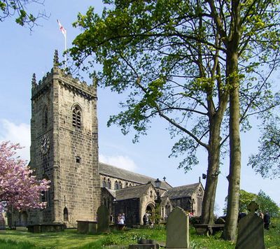
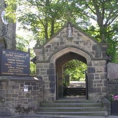
Church of St Oswald, Medieval church in Guiseley, England

The Church of St Oswald is a medieval structure in Guiseley featuring Norman architectural traits including pointed arches and detailed stone carvings, complemented by stained glass windows throughout its interior. The building displays the typical features expected of early ecclesiastical construction from that period.

The church originates from around 1050 and represents early medieval ecclesiastical construction in West Yorkshire during a formative period for English Christianity. Its survival through the centuries demonstrates the enduring role of religious institutions in this region.

The church is named after Saint Oswald, a king of Northumbria whose veneration reflects the deep bonds between Christianity and northern England during medieval times. Visitors can sense this religious importance woven throughout the building's design and furnishings.

Visitors can explore the church during regular opening hours and examine the architectural details both inside and out at their own pace. It is helpful to check ahead about access options and any available guidance to make the most of your visit.

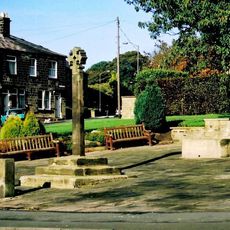
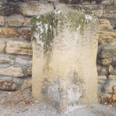
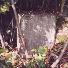
On the church grounds stand two pre-Norman stone cross shafts from the 9th century carved with apostles, dragons, and runic inscriptions. These rare artifacts offer glimpses into early British Christian art and craftsmanship.

Location: Leeds

Inception: 11 century

GPS coordinates: 53.87520,-1.70619

Latest update: December 14, 2025 14:45

Photos
Around this place
Yeadon Town Hall
United Kingdom

Yeadon Town Hall

1.7 km
Esholt Priory
United Kingdom

Esholt Priory

2.5 km
Guiseley Theatre
United Kingdom

Guiseley Theatre

351 m
Church of St Andrew
United Kingdom

Church of St Andrew

1.6 km
Church of St Paul
United Kingdom

Church of St Paul

2.3 km
Hawksworth Hall
United Kingdom

Hawksworth Hall

2.5 km
Trinity Church
United Kingdom

Trinity Church

2.3 km
The Commercial Inn
United Kingdom

The Commercial Inn

2.2 km
Menston Library
United Kingdom

Menston Library

2.7 km
Yeadon Library
United Kingdom

Yeadon Library

1.8 km
Rawdon Community Library
United Kingdom

Rawdon Community Library

2.7 km
Esholt Viaduct
United Kingdom

Esholt Viaduct

2.1 km
Trinity Church Sunday School
United Kingdom

Trinity Church Sunday School

2.2 km
Guiseley Library
United Kingdom

Guiseley Library

360 m
Guiseley War Memorial Garden
United Kingdom

Guiseley War Memorial Garden

108 m
Lychgate to Church of St Oswald
United Kingdom

Lychgate to Church of St Oswald

33 m
Guidestone, Victoria Road, N of tunnel under L&B airport runway, jct of Warren House Lane
United Kingdom

Guidestone, Victoria Road, N of tunnel under L&B airport runway, jct of Warren House Lane

2.7 km
K6 Telephone Kiosk Outside Number 21 (The Post Office)
United Kingdom

K6 Telephone Kiosk Outside Number 21 (The Post Office)

2.2 km
Cup and ring marked rock known as the Knotties Stone on Otley Chevin, 270m north east of The Royalty public house
United Kingdom

Cup and ring marked rock known as the Knotties Stone on Otley Chevin, 270m north east of The Royalty public house

2.4 km
Gate Lodge And Gate Piers To Park Gate House
United Kingdom

Gate Lodge And Gate Piers To Park Gate House

1 km
13-21, Main Street
United Kingdom

13-21, Main Street

2.2 km
Milestone, Victoria Avenue; TI north of tunnel under L&B airport runway
United Kingdom

Milestone, Victoria Avenue; TI north of tunnel under L&B airport runway

2.7 km
Milestone, Bradford Road nr Post office, S of Tranmere Drive
United Kingdom

Milestone, Bradford Road nr Post office, S of Tranmere Drive

1.3 km
Yeadon Liberal Club
United Kingdom

Yeadon Liberal Club

1.8 km
Milestone, New Road, Yeadon
United Kingdom

Milestone, New Road, Yeadon

1.6 km
Milestone, Harrogate Road, Rawdon
United Kingdom

Milestone, Harrogate Road, Rawdon

2.6 km
Milestone, Otley Road , Guiseley
United Kingdom

Milestone, Otley Road , Guiseley

379 m
Milestone, Otley Road, Hollins Hill, Hawkswood
United Kingdom

Milestone, Otley Road, Hollins Hill, Hawkswood

1.9 km
Show the full map
Reviews

Visited this place? Tap the stars to rate it and share your experience / photos with the community! Try now! You can cancel it anytime.

« Church of St Oswald - Medieval church in Guiseley, England » is provided by Around Us (aroundus.com). Images and texts are derived from Wikimedia project under a Creative Commons license. You are allowed to copy, distribute, and modify copies of this page, under the conditions set by the license, as long as this note is clearly visible.

Discover hidden gems everywhere you go!

From secret cafés to breathtaking viewpoints, skip the crowded tourist spots and find places that match your style. Our app makes it easy with voice search, smart filtering, route optimization, and insider tips from travelers worldwide. Download now for the complete mobile experience.

Around Us App Screenshot

A unique approach to discovering new places

Le Figaro

All the places worth exploring

France Info

A tailor-made excursion in just a few clicks

20 Minutes