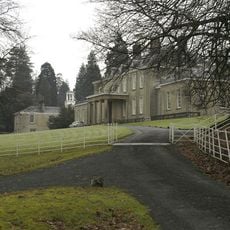
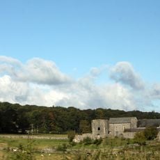
Ashton House, Grade II* listed house in Beetham, England
Ashton House stands with traditional English residential architecture, displaying detailed craftsmanship in its exterior features and structural elements from its construction period.
The historic building received its Grade II* designation on November 21, 1952, marking its recognition as a structure of particular national importance.
Through generations, Ashton House has maintained its architectural identity within Beetham village, representing the preservation standards of England's heritage registration system.
The structure coordinates at latitude 54.2085 and longitude -2.77431, registered under National Heritage List number 1087330, making it traceable for architectural research.
The residence incorporates construction methods and materials that exemplify architectural practices from its era, setting standards for preservation in Cumbria.
Location: Beetham
GPS coordinates: 54.20850,-2.77431
Latest update: March 5, 2025 00:18
Dallam Tower
1.7 km
St Michael's Church, Beetham
101 m
Heron Corn Mill
508 m
St Thomas' Church, Milnthorpe
2.1 km
Milepost Approximately 300 Metres North Of Holme Park
3.4 km
Hazelslack Tower
2.1 km
Holme Mill Bridge Over Kendal/Lancaster Canal
3.3 km
Holme Warehouse Bridge Over Kendal/Lancaster Canal
3 km
Sheerness Bridge Over Kendal/Lancaster Canal
3.2 km
Holme Park Bridge Over Kendal/Lancaster Canal
3 km
Boundary Post Approximately 650 Metres North East Of Holme Parish Church
2.3 km
Braithwaite Bridge Over Kendal/Lacaster Canal
3.3 km
Boundary Post At Junction Of B6384 With Paradise Lane Between Ackenthwaite And Whasset
2.3 km
Market Cross
2 km
Beetham War Memorial
130 m
Beetham Hall And Attached Outbuildings
527 m
Nelson's Bridge Over Kendal/Lancaster Canal
3.1 km
Milestone On Kendal/Lancaster Canal Approximately 100 Metres South Of Holme Warehouse Bridge
3 km
Holme Turnpike Bridge Over Kendal/Lancaster Canal
3.2 km
Kendal/Lancaster Canal Garth's Bridge Over Kendal
3.3 km
Footbridge over River Bela approximately 400 metres east-north-east of Milnthorpe Bridge
2 km
Janson's Bridge Over Kendal/Lancaster Canal
3.1 km
Milestone Approximately 350 Metres North West Of Junction With Pye's Bridge Lane
910 m
Milestone On Kendal/Lancaster Canal Approximately 70 Metres North Of Braithwaite Bridge
3.3 km
Milestone Approximately 150 Meters North North West Of Junction With Paradise Lane North Of Beetham
730 m
Boundary Stone At Entrance To Hawbarrow House
3.1 km
Milestone Approximately 60 Metres South Of Junction Of A6 With Moss Lane
2.4 km
Milepost, Haverflatts, opp. St Anthony's House
2.9 kmReviews
Visited this place? Tap the stars to rate it and share your experience / photos with the community! Try now! You can cancel it anytime.
Discover hidden gems everywhere you go!
From secret cafés to breathtaking viewpoints, skip the crowded tourist spots and find places that match your style. Our app makes it easy with voice search, smart filtering, route optimization, and insider tips from travelers worldwide. Download now for the complete mobile experience.
A unique approach to discovering new places❞
— Le Figaro
All the places worth exploring❞
— France Info
A tailor-made excursion in just a few clicks❞
— 20 Minutes