Enable Location

We need your location to show you interesting places around you

Discover nearby places

Find interesting locations and hidden gems around you

Precise directions

Get accurate directions and distances to places

Your location is never shared with other users. It's only used when you tap the location button.

Yair Bridge

Log in to your account

Start exploring — it's free

Trusted by 62,594 travelers worldwide

Continue with Google
Continue with Apple
or

We will send you a code to connect

By continuing, you accept our Terms and Conditions and our Privacy Policy

Check your inbox

We've sent a pincode in your inbox. Please enter the code below.

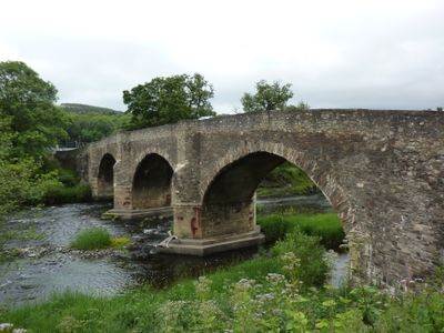
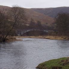
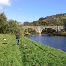
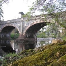
Yair Bridge, Stone arch bridge in Caddonfoot, Scottish Borders, United Kingdom.

The Yair Bridge is a stone arch bridge spanning the River Tweed with three regularly spaced arches. The structure connects both riverbanks with a broad roadway that now carries traffic on the A707.

Construction was completed in 1764 by William Mylne following parliamentary funding approval for the bridge and surrounding road infrastructure. This project was part of a broader effort to improve transport connections across the Scottish Borders.

The bridge takes its name from the nearby Yair plain and has become a landmark of the region. Visitors notice how naturally it fits within the Tweed valley landscape.

Pedestrians find small stone refuges along the sides for stepping aside from vehicle traffic. The best time to visit is during daylight hours when the river landscape and stone details are clearly visible.

The construction displays two different techniques: finely dressed blocks form the piers, while rougher stone was used in other sections. This combination was a practical way to manage costs in early bridge-building projects.

The community of curious travelers

AroundUs brings together thousands of curated places, local tips, and hidden gems, enriched daily by 60,000 contributors worldwide.

Start exploring
Location
Location
Official opening
1764
Made from material
stone
Part of
Yair estate
GPS coordinates
55.58360,-2.86112
Latest update
December 14, 2025 17:42
Around this place
High Sunderland, Galashiels, Including Boundary Walls And Gate Piers
United Kingdom

High Sunderland, Galashiels, Including Boundary Walls And Gate Piers

1.9 km
Yair estate
United Kingdom

Yair estate

591 m
Peel House
United Kingdom

Peel House

3.4 km
Ashiestiel Bridge
United Kingdom

Ashiestiel Bridge

3.2 km
Selkirk, Dunsdale Road, Ettrick Mill
United Kingdom

Selkirk, Dunsdale Road, Ettrick Mill

3.5 km
Yair House
United Kingdom

Yair House

603 m
Selkirk, Bleachfield Road, St John's Episcopal Church
United Kingdom

Selkirk, Bleachfield Road, St John's Episcopal Church

3.9 km
Tweed Bridge
United Kingdom

Tweed Bridge

3 km
Bernat Klein Studio
United Kingdom

Bernat Klein Studio

2 km
Ettrick Bridge
United Kingdom

Ettrick Bridge

2.9 km
110 Forest Road, Selkirk
United Kingdom

110 Forest Road, Selkirk

4 km
Corn Mill, Station Road, Selkirk
United Kingdom

Corn Mill, Station Road, Selkirk

3.9 km
Selkirk, Station Road, Forest Mill
United Kingdom

Selkirk, Station Road, Forest Mill

3.9 km
Selkirk, Bleachfield Road, St John's Episcopal Church, Church Hall
United Kingdom

Selkirk, Bleachfield Road, St John's Episcopal Church, Church Hall

3.9 km
Hillcrest, Shawpark Road, Selkirk
United Kingdom

Hillcrest, Shawpark Road, Selkirk

3.9 km
Gatepiers, Dandswall, 10 & 12 Shawpark Road, 8, Selkirk
United Kingdom

Gatepiers, Dandswall, 10 & 12 Shawpark Road, 8, Selkirk

4 km
52, 54 Mill Street, Selkirk
United Kingdom

52, 54 Mill Street, Selkirk

4 km
Outbuilding, Lodge, 1 Thornfield Avenue, Selkirk
United Kingdom

Outbuilding, Lodge, 1 Thornfield Avenue, Selkirk

3.9 km
Belmont, Mavis Bank, Selkirk
United Kingdom

Belmont, Mavis Bank, Selkirk

3.7 km
Weaving Factory, 66-74 Mill Street, Selkirk
United Kingdom

Weaving Factory, 66-74 Mill Street, Selkirk

4 km
Dandswall, 10 & 12 Shawpark Road, 8, Selkirk
United Kingdom

Dandswall, 10 & 12 Shawpark Road, 8, Selkirk

3.9 km
Rink Hill
United Kingdom

Rink Hill

2.6 km
15 Scotts Place, Selkirk
United Kingdom

15 Scotts Place, Selkirk

4 km
9 Scotts Place, Selkirk
United Kingdom

9 Scotts Place, Selkirk

4 km
Selkirk,14 Shawpark Road, Dandswall Lodge, Stable & Gatepiers
United Kingdom

Selkirk,14 Shawpark Road, Dandswall Lodge, Stable & Gatepiers

3.9 km
Wall Letter Box, North Side, Scott's Place, Selkirk
United Kingdom

Wall Letter Box, North Side, Scott's Place, Selkirk

4 km
Lodge, 1 Thornfield Avenue, Selkirk
United Kingdom

Lodge, 1 Thornfield Avenue, Selkirk

3.9 km
Selkirk, 18 Shawpark Road
United Kingdom

Selkirk, 18 Shawpark Road

4 km
Show the full map
« Yair Bridge - Stone arch bridge in Caddonfoot, Scottish Borders, United Kingdom » is provided by Around Us (aroundus.com). Images and texts are derived from Wikimedia project under a Creative Commons license. You are allowed to copy, distribute, and modify copies of this page, under the conditions set by the license, as long as this note is clearly visible.

Discover hidden gems everywhere you go!

From secret cafés to breathtaking viewpoints, skip the crowded tourist spots and find places that match your style. Our app makes it easy with voice search, smart filtering, route optimization, and insider tips from travelers worldwide. Download now for the complete mobile experience.

Around Us App Screenshot

A unique approach to discovering new places

Le Figaro

All the places worth exploring

France Info

A tailor-made excursion in just a few clicks

20 Minutes

Around Us
Travel Guide & Maps
Download

Send to your phone

QR Code
1

Open the camera app on your mobile.

2

Point at the QR code with your camera. A notification will appear.

3

Tap the notification to open the link.