Enable Location

We need your location to show you interesting places around you

Discover nearby places

Find interesting locations and hidden gems around you

Precise directions

Get accurate directions and distances to places

Your location is never shared with other users. It's only used when you tap the location button.

新荒川大橋

Log in to your account

Start exploring — it's free

Trusted by 61,993 travelers worldwide

Continue with Google
Continue with Apple
or

We will send you a code to connect

By continuing, you accept our Terms and Conditions and our Privacy Policy

Check your inbox

We've sent a pincode in your inbox. Please enter the code below.

新荒川大橋

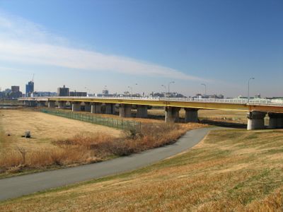
新荒川大橋, Road bridge across Arakawa River in Tokyo, Japan

Shin-Arakawa Bridge is a road bridge crossing the Arakawa River and connecting Kawaguchi in Saitama Prefecture with Kita Ward in Tokyo. The structure consists of two parallel spans completed in the 1960s and 1970s, together forming National Route 122.

The original bridge was completed in 1928, replacing a ferry service and becoming the longest bridge in Tokyo at that time. A second parallel span was added decades later to handle increasing traffic demands.

The bridge represents a daily crossing point where commuters and residents move between two prefectures, serving as a practical link in the region's urban fabric. It marks the boundary where Saitama and Tokyo meet, making it a significant geographical marker in everyday life.

The bridge is easily accessible when traveling between the two prefectures by car or public transport. Pedestrians and cyclists can cross the structure, though they should be aware of steady vehicle traffic as this is a well-used transportation route.

During the 2011 earthquake, the tsunami passed beneath the bridge without damaging it, making it a notable point of resilience during that disaster. This event highlighted how the structure was designed to withstand natural forces affecting the region.

The community of curious travelers

AroundUs brings together thousands of curated places, local tips, and hidden gems, enriched daily by 60,000 contributors worldwide.

Start exploring
GPS coordinates
35.78972,139.72389
Latest update
December 10, 2025 16:26
« 新荒川大橋 - Road bridge across Arakawa River in Tokyo, Japan » is provided by Around Us (aroundus.com). Images and texts are derived from Wikimedia project under a Creative Commons license. You are allowed to copy, distribute, and modify copies of this page, under the conditions set by the license, as long as this note is clearly visible.

Discover hidden gems everywhere you go!

From secret cafés to breathtaking viewpoints, skip the crowded tourist spots and find places that match your style. Our app makes it easy with voice search, smart filtering, route optimization, and insider tips from travelers worldwide. Download now for the complete mobile experience.

Around Us App Screenshot

A unique approach to discovering new places

Le Figaro

All the places worth exploring

France Info

A tailor-made excursion in just a few clicks

20 Minutes

Around Us
Travel Guide & Maps
Download

Send to your phone

QR Code
1

Open the camera app on your mobile.

2

Point at the QR code with your camera. A notification will appear.

3

Tap the notification to open the link.