Enable Location

We need your location to show you interesting places around you

Discover nearby places

Find interesting locations and hidden gems around you

Precise directions

Get accurate directions and distances to places

Your location is never shared with other users. It's only used when you tap the location button.

Правобережное Цимлянское городище

Log in to your account

Start exploring — it's free

Trusted by 62,292 travelers worldwide

Continue with Google
Continue with Apple
or

We will send you a code to connect

By continuing, you accept our Terms and Conditions and our Privacy Policy

Check your inbox

We've sent a pincode in your inbox. Please enter the code below.

Правобережное Цимлянское городище

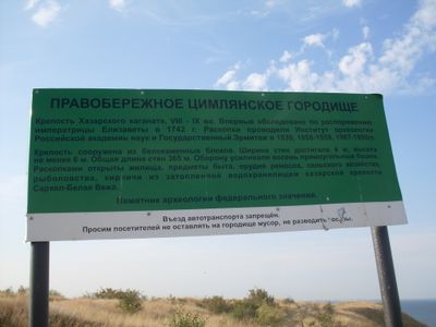
Правобережное Цимлянское городище, Medieval hillfort in Tsimlyansk, Russia

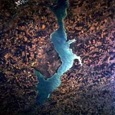
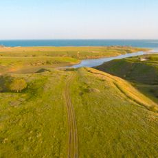
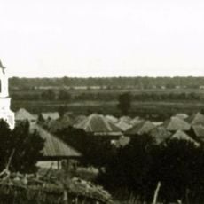
The Right Bank Tsimlyansk Oppidum is an archaeological fortification situated on a high plateau overlooking the reservoir. The terrain is ringed by natural gorges that provide protection on multiple sides of the site.

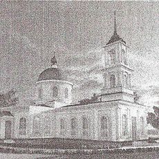
The fortress was constructed in the late 7th century as a Khazar military stronghold controlling the region. The building technique using white stone blocks reinforced with wooden beams represented advanced engineering for that era.

The site functions today as an open archaeological area where visitors can observe the physical remains of ancient fortifications. The exposed structures give a sense of how communities once organized their defenses in this region.

The site is protected under federal archaeological regulations that limit how visitors can engage with the area. Plan for uneven ground and follow any marked pathways or guidance from local authorities.

A 2009 excavation uncovered a wide range of metal artifacts and pottery that reveal the extent of craft production and trade activity at this fortress. The finds suggest the settlement was not merely a military outpost but an economically active community.

The community of curious travelers

AroundUs brings together thousands of curated places, local tips, and hidden gems, enriched daily by 60,000 contributors worldwide.

Start exploring
Location
GPS coordinates
47.68450,42.16860
Latest update
December 13, 2025 12:25
Around this place
Tsimlyansk Reservoir
Russian Federation

Tsimlyansk Reservoir

52.4 km
Veselovsky Reservoir
Russian Federation

Veselovsky Reservoir

107.9 km
Peaceful Atom
Russian Federation

Peaceful Atom

18.5 km
Volgodonsk Arboretum
Russian Federation

Volgodonsk Arboretum

19.2 km
Цимлянск (заказник)
Russian Federation

Цимлянск (заказник)

38.3 km
Cathedral of the Nativity, Volgodonsk
Russian Federation

Cathedral of the Nativity, Volgodonsk

18.1 km
Парк Перемоги (Волгодонськ)
Russian Federation

Парк Перемоги (Волгодонськ)

18.7 km
Tulips peninsula
Russian Federation

Tulips peninsula

89.5 km
Church of the Ascension, Susat
Russian Federation

Church of the Ascension, Susat

113.8 km
Cossacks
Russian Federation

Cossacks

15 km
Ethnographic Museum, Razdorskaya
Russian Federation

Ethnographic Museum, Razdorskaya

115.1 km
Church of the Intercession
Russian Federation

Church of the Intercession

81.8 km
Николай Чудотворец сиркәүе
Russian Federation

Николай Чудотворец сиркәүе

81.1 km
Museum of Local History of Volgodonsk District
Russian Federation

Museum of Local History of Volgodonsk District

34.7 km
Ang Simbahan Sa Pagpangamuyo Sa Bulahan Nga Birhen Maria
Russian Federation

Ang Simbahan Sa Pagpangamuyo Sa Bulahan Nga Birhen Maria

82.6 km
Крымское городище (Ростовская область)
Russian Federation

Крымское городище (Ростовская область)

105.8 km
St. Nicholas' Church, Tsimlyansk
Russian Federation

St. Nicholas' Church, Tsimlyansk

7.1 km
Volgodonsk Ecological and Historical Museum
Russian Federation

Volgodonsk Ecological and Historical Museum

19.2 km
Church of the Nativity of the Blessed Virgin Mary
Russian Federation

Church of the Nativity of the Blessed Virgin Mary

111.2 km
Simbahan Sa Mga Pangagpas Sa Bulahan Nga Birhen Maria
Russian Federation

Simbahan Sa Mga Pangagpas Sa Bulahan Nga Birhen Maria

99 km
Бекрен исемендәге Изге Николай монастыры
Russian Federation

Бекрен исемендәге Изге Николай монастыры

33.7 km
Ang Simbahan Ni Belen Sa Bulahan Nga Birhen Maria
Russian Federation

Ang Simbahan Ni Belen Sa Bulahan Nga Birhen Maria

88.2 km
Ilyinskaya church
Russian Federation

Ilyinskaya church

96.3 km
Holy Trinity Church, Bolshaya Martynovka
Russian Federation

Holy Trinity Church, Bolshaya Martynovka

58.9 km
Богоявленская церковь (Кумшацкая)
Russian Federation

Богоявленская церковь (Кумшацкая)

14.6 km
Дуб черешчатый (Ростовская область)
Russian Federation

Дуб черешчатый (Ростовская область)

83.5 km
Цимлянский районный краеведческий музей
Russian Federation

Цимлянский районный краеведческий музей

6.2 km
Port Volgodonsk
Russian Federation

Port Volgodonsk

15.7 km
Show the full map
« Правобережное Цимлянское городище - Medieval hillfort in Tsimlyansk, Russia » is provided by Around Us (aroundus.com). Images and texts are derived from Wikimedia project under a Creative Commons license. You are allowed to copy, distribute, and modify copies of this page, under the conditions set by the license, as long as this note is clearly visible.

Discover hidden gems everywhere you go!

From secret cafés to breathtaking viewpoints, skip the crowded tourist spots and find places that match your style. Our app makes it easy with voice search, smart filtering, route optimization, and insider tips from travelers worldwide. Download now for the complete mobile experience.

Around Us App Screenshot

A unique approach to discovering new places

Le Figaro

All the places worth exploring

France Info

A tailor-made excursion in just a few clicks

20 Minutes

Around Us
Travel Guide & Maps
Download

Send to your phone

QR Code
1

Open the camera app on your mobile.

2

Point at the QR code with your camera. A notification will appear.

3

Tap the notification to open the link.