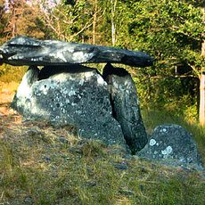
Stala 84:1, röse i Bohuslän
Location: Orust Municipality
GPS coordinates: 58.13032,11.60374
Latest update: November 22, 2025 18:34
Haga dolmen
1.2 km
Orust markettown
1.1 km
Tegneby 118:1
1.6 km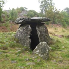
Haga dösen
1.2 km
Tegneby 89:1
1.2 km
Mégalithe de Stala socken
320 m
Saxerös
1.3 km
Tegneby 408:1
1.3 km
Tegneby 131:1
1.1 km
Tegneby 95:1
475 m
Guldknapp
1.2 km
Kisteröset
663 m
30
1.3 km
Tegneby 408:2
1.3 km
Tegneby 136:2
1.1 km
Tösen
421 m
Tegneby 139:1
1.6 km
Tegneby 183:1
1.3 km
Kullbergs slott
1 km
Tegneby 100:1
482 m
Kisteröset
669 m
Tegneby 126:1
1.3 km
Tegneby 94:1
207 m
Tegneby 130:1
1.6 km
Tegneby 141:1
1.5 km
Tegneby 141:2
1.5 km
Tegneby 141:3
1.5 km
Tegneby 141:4
1.5 kmReviews
Visited this place? Tap the stars to rate it and share your experience / photos with the community! Try now! You can cancel it anytime.
Discover hidden gems everywhere you go!
From secret cafés to breathtaking viewpoints, skip the crowded tourist spots and find places that match your style. Our app makes it easy with voice search, smart filtering, route optimization, and insider tips from travelers worldwide. Download now for the complete mobile experience.

A unique approach to discovering new places❞
— Le Figaro
All the places worth exploring❞
— France Info
A tailor-made excursion in just a few clicks❞
— 20 Minutes