Enable Location

We need your location to show you interesting places around you

Discover nearby places

Find interesting locations and hidden gems around you

Precise directions

Get accurate directions and distances to places

Your location is never shared with other users. It's only used when you tap the location button.

Kerr Lake State Recreation Area

Log in to your account

Start exploring — it's free

Trusted by 61,973 travelers worldwide

Continue with Google
Continue with Apple
or

We will send you a code to connect

By continuing, you accept our Terms and Conditions and our Privacy Policy

Check your inbox

We've sent a pincode in your inbox. Please enter the code below.

Kerr Lake State Recreation Area

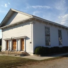
Kerr Lake State Recreation Area, State recreation area in Henderson, North Carolina.

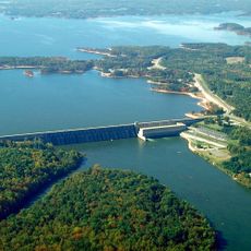
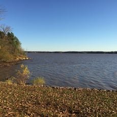
Kerr Lake State Recreation Area is a recreation area built around a large reservoir in North Carolina with eight access points along its shoreline. The facility features campgrounds and boat launching areas spread across the region, with supporting buildings and utilities for visitors.

This recreation area was established in 1981 by the North Carolina State Parks system to open access to the large reservoir and its surroundings. The various access points and facilities were developed over time to accommodate growing visitor needs.

The recreation area serves as a gathering place for local communities through its amphitheater programs, educational events, and interpretive sessions about North Carolina's environment.

Seven campgrounds are distributed across the area with various amenities including electric hookups and shower buildings. The visitor center helps you plan which access points work best for your intended activities.

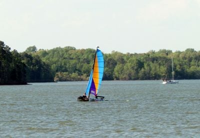
The lake holds an exceptional mix of fish species and ranks among the most productive fishing locations in the eastern United States. This reputation draws anglers from afar who come to test their skills on these waters.

The community of curious travelers

AroundUs brings together thousands of curated places, local tips, and hidden gems, enriched daily by 60,000 contributors worldwide.

Start exploring
Location
Inception
1981
GPS coordinates
36.44860,-78.37190
Latest update
December 11, 2025 18:04
Around this place
John H. Kerr Dam
United States of America

John H. Kerr Dam

17.9 km
Occoneechee State Park
United States of America

Occoneechee State Park

20.1 km
United States of America

Long Grass Plantation

12 km
Burnside Plantation House
United States of America

Burnside Plantation House

8.3 km
Ashland
United States of America

Ashland

1.9 km
Mecklenburg County Courthouse
United States of America

Mecklenburg County Courthouse

24.3 km
Boyd's Tavern
United States of America

Boyd's Tavern

24.4 km
Buckingham Courthouse Historic District
United States of America

Buckingham Courthouse Historic District

19.8 km
Pool Rock Plantation
United States of America

Pool Rock Plantation

4.2 km
St. John's Episcopal Church
United States of America

St. John's Episcopal Church

6 km
Oxford Historic District
United States of America

Oxford Historic District

24.8 km
Warrenton Historic District
United States of America

Warrenton Historic District

20.3 km
Green Duke House
United States of America

Green Duke House

13.2 km
Granville County Courthouse
United States of America

Granville County Courthouse

24.6 km
Henderson Central Business Historic District
United States of America

Henderson Central Business Historic District

14 km
Zollicoffer's Law Office
United States of America

Zollicoffer's Law Office

13.7 km
Eureka
United States of America

Eureka

23.9 km
Vance County Courthouse
United States of America

Vance County Courthouse

13.6 km
Elm Hill
United States of America

Elm Hill

19.3 km
Library and Laboratory Building-Henderson Institute
United States of America

Library and Laboratory Building-Henderson Institute

12.6 km
Boydton Historic District
United States of America

Boydton Historic District

24.3 km
Chapel of the Good Shepherd
United States of America

Chapel of the Good Shepherd

13.4 km
On the Hill
United States of America

On the Hill

24.2 km
Mansfield Thornton House
United States of America

Mansfield Thornton House

21.4 km
William J. Hawkins House
United States of America

William J. Hawkins House

11.7 km
Salem Methodist Church
United States of America

Salem Methodist Church

18.6 km
Joseph B. Littlejohn House
United States of America

Joseph B. Littlejohn House

24.1 km
Elm Hill Archaeological Site
United States of America

Elm Hill Archaeological Site

20.3 km
Show the full map
« Kerr Lake State Recreation Area - State recreation area in Henderson, North Carolina » is provided by Around Us (aroundus.com). Images and texts are derived from Wikimedia project under a Creative Commons license. You are allowed to copy, distribute, and modify copies of this page, under the conditions set by the license, as long as this note is clearly visible.

Discover hidden gems everywhere you go!

From secret cafés to breathtaking viewpoints, skip the crowded tourist spots and find places that match your style. Our app makes it easy with voice search, smart filtering, route optimization, and insider tips from travelers worldwide. Download now for the complete mobile experience.

Around Us App Screenshot

A unique approach to discovering new places

Le Figaro

All the places worth exploring

France Info

A tailor-made excursion in just a few clicks

20 Minutes

Around Us
Travel Guide & Maps
Download

Send to your phone

QR Code
1

Open the camera app on your mobile.

2

Point at the QR code with your camera. A notification will appear.

3

Tap the notification to open the link.