Enable Location

We need your location to show you interesting places around you

Discover nearby places

Find interesting locations and hidden gems around you

Precise directions

Get accurate directions and distances to places

Your location is never shared with other users. It's only used when you tap the location button.

Little Cacapon Mountain

Log in to your account

Start exploring — it's free

Trusted by 62,396 travelers worldwide

Continue with Google
Continue with Apple
or

We will send you a code to connect

By continuing, you accept our Terms and Conditions and our Privacy Policy

Check your inbox

We've sent a pincode in your inbox. Please enter the code below.

Little Cacapon Mountain

Little Cacapon Mountain, Mountain summit in Hampshire County, West Virginia, United States.

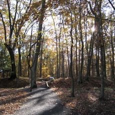
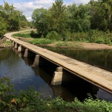
Little Cacapon Mountain is a summit in Hampshire County rising to about 1,575 feet (480 meters) in the Ridge-and-Valley Appalachians. The mountain stretches between Chestnut Oak Ridge and Slanesville Pike, with the Little Cacapon River flowing along its western edge.

Native American tribes hunted and settled in this mountain area long before European colonists arrived in the region. The presence of these early inhabitants shaped the landscape and left lasting marks reflected in the names still used today.

The name Cacapon comes from indigenous languages and reflects the connection between this mountain and its first inhabitants. You still hear this name used throughout the area today, linking visitors to the region's deeper past.

Multiple access points to the mountain are available through local roads, with spring and fall offering the most pleasant hiking conditions. Check weather forecasts before your visit, as seasonal changes can affect how easily you can reach various points on the mountain.

The mountain overlooks the Little Cacapon River flowing along its western slope, creating a natural boundary in the landscape. This waterway was essential to the people who lived in the region long ago.

The community of curious travelers

AroundUs brings together thousands of curated places, local tips, and hidden gems, enriched daily by 60,000 contributors worldwide.

Start exploring
Location
Part of
Ridge-and-Valley Appalachians
GPS coordinates
39.35010,-78.61029
Latest update
December 14, 2025 17:40
Around this place
Literary Hall
United States of America

Literary Hall

12.6 km
Sloan–Parker House
United States of America

Sloan–Parker House

21 km
Valley View
United States of America

Valley View

12.9 km
Indian Mound Cemetery
United States of America

Indian Mound Cemetery

13.4 km
Washington Bottom Farm
United States of America

Washington Bottom Farm

13.1 km
Fort Ashby
United States of America

Fort Ashby

21.8 km
Confederate Memorial
United States of America

Confederate Memorial

13.4 km
Fort Mill Ridge Civil War Trenches
United States of America

Fort Mill Ridge Civil War Trenches

16 km
United States of America

Piss Pot Island

14.8 km
Wilson-Wodrow-Mytinger House
United States of America

Wilson-Wodrow-Mytinger House

12.7 km
Hampshire County Courthouse
United States of America

Hampshire County Courthouse

12.6 km
Taggart Hall
United States of America

Taggart Hall

12.7 km
Washington Place
United States of America

Washington Place

12.2 km
Michael Cresap House
United States of America

Michael Cresap House

21.3 km
French's Mill
United States of America

French's Mill

6.7 km
Scanlon Farm
United States of America

Scanlon Farm

5.7 km
North River Mills Historic District
United States of America

North River Mills Historic District

9.3 km
Nathaniel and Isaac Kuykendall House
United States of America

Nathaniel and Isaac Kuykendall House

18.2 km
Hickory Grove
United States of America

Hickory Grove

14.9 km
Yellow Spring Mill
United States of America

Yellow Spring Mill

20.6 km
Carskadon House
United States of America

Carskadon House

21.1 km
Camp Waldo Schmitt
United States of America

Camp Waldo Schmitt

2.8 km
Old Methodist District Parsonage
United States of America

Old Methodist District Parsonage

12.5 km
Old Capon Bridge Christian Church
United States of America

Old Capon Bridge Christian Church

16.1 km
Abraham Kackley House
United States of America

Abraham Kackley House

18.3 km
Gower House
United States of America

Gower House

16.5 km
169 East Main Street (Romney, West Virginia)
United States of America

169 East Main Street (Romney, West Virginia)

12.5 km
Oldtown Bridge
United States of America

Oldtown Bridge

20.9 km
Show the full map
« Little Cacapon Mountain - Mountain summit in Hampshire County, West Virginia, United States » is provided by Around Us (aroundus.com). Images and texts are derived from Wikimedia project under a Creative Commons license. You are allowed to copy, distribute, and modify copies of this page, under the conditions set by the license, as long as this note is clearly visible.

Discover hidden gems everywhere you go!

From secret cafés to breathtaking viewpoints, skip the crowded tourist spots and find places that match your style. Our app makes it easy with voice search, smart filtering, route optimization, and insider tips from travelers worldwide. Download now for the complete mobile experience.

Around Us App Screenshot

A unique approach to discovering new places

Le Figaro

All the places worth exploring

France Info

A tailor-made excursion in just a few clicks

20 Minutes

Around Us
Travel Guide & Maps
Download

Send to your phone

QR Code
1

Open the camera app on your mobile.

2

Point at the QR code with your camera. A notification will appear.

3

Tap the notification to open the link.