Enable Location

We need your location to show you interesting places around you

Discover nearby places

Find interesting locations and hidden gems around you

Precise directions

Get accurate directions and distances to places

Your location is never shared with other users. It's only used when you tap the location button.

Log in to your account

Start exploring — it's free

Trusted by 62,475 travelers worldwide

Continue with Google
Continue with Apple
or

We will send you a code to connect

By continuing, you accept our Terms and Conditions and our Privacy Policy

Check your inbox

We've sent a pincode in your inbox. Please enter the code below.

Mountain Meadow Preserve

Mountain Meadow Preserve, Protected area in Williamstown, Massachusetts, US.

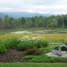
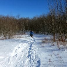
Mountain Meadow Preserve is a protected area located between the Berkshires and Green Mountains in Massachusetts, encompassing highland meadows, wetlands, and forested hillsides. The property offers multiple trail routes that guide visitors through different landscape types and enable nature observation.

The preserve was established in 1998 when Pamela B. Weatherbee donated the property to The Trustees of Reservations, a conservation organization. This gift secured long-term protection of the land for nature conservation and public access to the natural landscape.

The preserve serves as a space where visitors can observe seasonal shifts in the local landscape and learn about the ecosystems through guided nature tours. The different trails connect open meadows with forested areas, allowing people to experience the full range of habitats the land contains.

The preserve can be accessed from two main starting points: Mason Road in Williamstown and White Oaks Road in Pownal, both offering parking. Visitors should bring weather-appropriate clothing and sturdy footwear, as the trails cross varied terrain.

From the elevated point at Mason Hill, visitors can see Mount Greylock and the Taconic Mountains in the distance, which is particularly visible from this higher vantage point. This raised position makes it easier to take in the distant mountain ridges surrounding the area.

The community of curious travelers

AroundUs brings together thousands of curated places, local tips, and hidden gems, enriched daily by 60,000 contributors worldwide.

Start exploring
Location
GPS coordinates
42.73850,-73.20760
Latest update
December 13, 2025 12:22
Around this place
Clark Art Institute
United States of America

Clark Art Institute

3.5 km
Massachusetts Museum of Contemporary Art
United States of America

Massachusetts Museum of Contemporary Art

8.5 km
Northern boundary of Massachusetts
United States of America

Northern boundary of Massachusetts

4.8 km
Field Farm
United States of America

Field Farm

9.2 km
Western Gateway Heritage State Park
United States of America

Western Gateway Heritage State Park

9 km
Wells House
United States of America

Wells House

7.5 km
Mooar-Wright House
United States of America

Mooar-Wright House

4.2 km
Hopkins Observatory
United States of America

Hopkins Observatory

3 km
1753 House
United States of America

1753 House

2.8 km
Congregation Beth Israel
United States of America

Congregation Beth Israel

5.5 km
Hillside Cemetery
United States of America

Hillside Cemetery

8.1 km
Church Street Historic District
United States of America

Church Street Historic District

9.4 km
Five Corners Historic District
United States of America

Five Corners Historic District

9.2 km
Hathaway Tenement
United States of America

Hathaway Tenement

8.1 km
St. Joseph's School
United States of America

St. Joseph's School

9.1 km
Boston Finishing Works
United States of America

Boston Finishing Works

3.6 km
Freeman's Grove Historic District
United States of America

Freeman's Grove Historic District

9.3 km
Williamstown Rail Yard and Station Historic District
United States of America

Williamstown Rail Yard and Station Historic District

2.5 km
Armstrong House
United States of America

Armstrong House

8.5 km
Crowley House
United States of America

Crowley House

7.8 km
Eber Sherman Farm
United States of America

Eber Sherman Farm

5.2 km
Mill Village Historic District
United States of America

Mill Village Historic District

2.8 km
William B. Sherman Farm
United States of America

William B. Sherman Farm

5 km
Col. Benjamin Simond House
United States of America

Col. Benjamin Simond House

991 m
Sykes House
United States of America

Sykes House

7.5 km
Williams College Museum of Art
United States of America

Williams College Museum of Art

3.1 km
Mount Raimer
United States of America

Mount Raimer

6.7 km
'62 Center for Theatre and Dance
United States of America

'62 Center for Theatre and Dance

2.8 km
Show the full map
« Mountain Meadow Preserve - Protected area in Williamstown, Massachusetts, US » is provided by Around Us (aroundus.com). Images and texts are derived from Wikimedia project under a Creative Commons license. You are allowed to copy, distribute, and modify copies of this page, under the conditions set by the license, as long as this note is clearly visible.

Discover hidden gems everywhere you go!

From secret cafés to breathtaking viewpoints, skip the crowded tourist spots and find places that match your style. Our app makes it easy with voice search, smart filtering, route optimization, and insider tips from travelers worldwide. Download now for the complete mobile experience.

Around Us App Screenshot

A unique approach to discovering new places

Le Figaro

All the places worth exploring

France Info

A tailor-made excursion in just a few clicks

20 Minutes

Around Us
Travel Guide & Maps
Download

Send to your phone

QR Code
1

Open the camera app on your mobile.

2

Point at the QR code with your camera. A notification will appear.

3

Tap the notification to open the link.