Musketawa Trail, National Recreation Trail in western Michigan, United States.
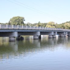
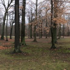
The Musketawa Trail is a 25-mile paved pathway through western Michigan connecting Muskegon and Marne, passing through farmland and wooded areas. The route features a 12-foot wide surface and includes 13 trestles along its length, with the longest bridge spanning 216 feet across Crockery Creek.
The route follows the former railroad line of the Muskegon, Grand Rapids and Indiana Railroad built in 1886. This line played a key role in transporting lumber during Michigan's timber boom in the late 1800s.
The name Musketawa came from a community contest combining the two counties it passes through. This blend reflects the connection between the communities linked by this route.
The trail has convenient access points near Marne and Conklin with parking available. Its wide, flat paved design makes it easy to walk or bike for people of all abilities.
The 13 trestles along this route are remnants of the original railroad infrastructure and showcase engineering from the late 1800s. These structures now serve as distinctive landmarks that recall the region's industrial past.
Location: Michigan
Website: http://musketawatrail.org
GPS coordinates: 43.15580,-85.90250
Latest update: December 14, 2025 14:24
Lubbers Stadium
20.8 km
Cook Carillon Tower
21.4 km
Kirkhof Center
21.5 km
Grant Depot and Water Tower
21.2 km
Battle Point Site
23.6 km
Villa Maria
25.2 km
Spoonville site
19.1 km
Monroe Avenue Water Filtration Plant
26.6 km
Fruitport Road–Pettys Bayou Bridge
23.4 km
Ahavas Israel Cemetery
24.2 km
Aloys Bilz House
25.8 km
Shawmut Hills Park
24.6 km
Tanglewood Park
25.9 km
Stocking Avenue Theatre
26.7 km
Hager Park
26.4 km
Our Theatre
25.8 km
Park Theatre
24.7 km
Lakeside Beach
24.5 km
Veterans' Facility Historical Marker
24.9 km
Roxy Theatre
26.5 km
Villa Maria Historical Marker
25.3 km
VanSteeland Arboretum
21.4 km
Grant Area District Library
21.4 km
Comstock Park Branch Library
23.5 km
Spring Lake District Library
25.4 km
Brann Building 401 Leonard Street
26.4 km
West Leonard Branch Library
25.5 km
Barber Briggs Historical Marker
26.3 kmVisited this place? Tap the stars to rate it and share your experience / photos with the community! Try now! You can cancel it anytime.
Discover hidden gems everywhere you go!
From secret cafés to breathtaking viewpoints, skip the crowded tourist spots and find places that match your style. Our app makes it easy with voice search, smart filtering, route optimization, and insider tips from travelers worldwide. Download now for the complete mobile experience.
A unique approach to discovering new places❞
— Le Figaro
All the places worth exploring❞
— France Info
A tailor-made excursion in just a few clicks❞
— 20 Minutes