Enable Location

We need your location to show you interesting places around you

Discover nearby places

Find interesting locations and hidden gems around you

Precise directions

Get accurate directions and distances to places

Your location is never shared with other users. It's only used when you tap the location button.

Battle Point Site

Log in to your account

Start exploring — it's free

Trusted by 62,797 travelers worldwide

Continue with Google
Continue with Apple
or

We will send you a code to connect

By continuing, you accept our Terms and Conditions and our Privacy Policy

Check your inbox

We've sent a pincode in your inbox. Please enter the code below.

Battle Point Site, archaeological site in Crockery Township, Michigan, USA

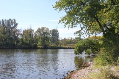
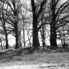
Battle Point Site is an archaeological place along a bend of the Grand River in Crockery Township, Michigan, where an Odawa village existed from roughly 1815 to 1835. The two-acre area contains a burial ground with approximately 20 graves and artifacts from trade goods including knives, axes, silver bracelets, and glass beads from Europe and America.

The village formed around 1815 under Chief Onamontapay and was abandoned in 1836 following a treaty that transferred land north of the Grand River to the United States. After removal, Chief Shiawassee of the Potawatomi attempted to organize resistance at the site but was peacefully prevented by community leaders, leading the Odawa to eventually leave the region.

The site was a center for the Odawa people who lived here and buried their dead while adopting some European burial practices such as orienting graves westward. The community maintained close relationships with early settlers who relied on their knowledge of food gathering and farming.

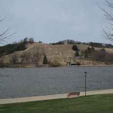
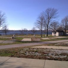
The site sits along the Grand River bank in Crockery Township and is largely invisible today due to erosion that has changed the shoreline over decades. Visitors should wear sturdy shoes and prepare for a location with minimal infrastructure.

The graves went hidden for decades until river erosion exposed them in the 1950s, prompting archaeologists to excavate the site in the 1970s. This accidental discovery through natural forces brought the Odawa burial legacy back to public attention.

The community of curious travelers

AroundUs brings together thousands of curated places, local tips, and hidden gems, enriched daily by 60,000 contributors worldwide.

Start exploring
GPS coordinates
43.03889,-86.14444
Latest update
February 9, 2026 07:42
Around this place
Pleasure Island
United States of America

Pleasure Island

13.2 km
Hoffmaster State Park
United States of America

Hoffmaster State Park

13.6 km
Grand Haven State Park
United States of America

Grand Haven State Park

8.5 km
Lubbers Stadium
United States of America

Lubbers Stadium

21.8 km
Pere Marquette 1223
United States of America

Pere Marquette 1223

7.7 km
Grand Haven Musical Fountain
United States of America

Grand Haven Musical Fountain

8.2 km
St. Francis de Sales Church
United States of America

St. Francis de Sales Church

21.7 km
Grand Haven South Pierhead Inner Light
United States of America

Grand Haven South Pierhead Inner Light

9.1 km
Grand Haven South Pierhead Entrance Light
United States of America

Grand Haven South Pierhead Entrance Light

9.3 km
Coast Guard Station Grand Haven
United States of America

Coast Guard Station Grand Haven

8 km
Cook Carillon Tower
United States of America

Cook Carillon Tower

22.5 km
Kirkhof Center
United States of America

Kirkhof Center

22.5 km
Grand Haven Historic District
United States of America

Grand Haven Historic District

7.8 km
Spoonville site
United States of America

Spoonville site

5.2 km
Grand Trunk Western Railroad Grand Haven Coal Tipple
United States of America

Grand Trunk Western Railroad Grand Haven Coal Tipple

7.7 km
Nathaniel and Esther Robbins House
United States of America

Nathaniel and Esther Robbins House

7.1 km
Edward P. Ferry House
United States of America

Edward P. Ferry House

7.1 km
Fruitport Road–Pettys Bayou Bridge
United States of America

Fruitport Road–Pettys Bayou Bridge

6.2 km
Aloys Bilz House
United States of America

Aloys Bilz House

6.2 km
Tri-Cities Historical Museum
United States of America

Tri-Cities Historical Museum

7.6 km
Tanglewood Park
United States of America

Tanglewood Park

6.2 km
Grand Haven 9
United States of America

Grand Haven 9

5.9 km
Pigeon Creek Park
United States of America

Pigeon Creek Park

12.7 km
Grand Haven North Pierhead Light
United States of America

Grand Haven North Pierhead Light

9.3 km
The Escanaba Historical Marker
United States of America

The Escanaba Historical Marker

7.9 km
Lakeside Beach
United States of America

Lakeside Beach

5.8 km
VanSteeland Arboretum
United States of America

VanSteeland Arboretum

22.6 km
Spring Lake District Library
United States of America

Spring Lake District Library

5.8 km
Show the full map
« Battle Point Site - archaeological site in Crockery Township, Michigan, USA » is provided by Around Us (aroundus.com). Images and texts are derived from Wikimedia project under a Creative Commons license. You are allowed to copy, distribute, and modify copies of this page, under the conditions set by the license, as long as this note is clearly visible.

Discover hidden gems everywhere you go!

From secret cafés to breathtaking viewpoints, skip the crowded tourist spots and find places that match your style. Our app makes it easy with voice search, smart filtering, route optimization, and insider tips from travelers worldwide. Download now for the complete mobile experience.

Around Us App Screenshot

A unique approach to discovering new places

Le Figaro

All the places worth exploring

France Info

A tailor-made excursion in just a few clicks

20 Minutes

Around Us
Travel Guide & Maps
Download

Send to your phone

QR Code
1

Open the camera app on your mobile.

2

Point at the QR code with your camera. A notification will appear.

3

Tap the notification to open the link.