Enable Location

We need your location to show you interesting places around you

Discover nearby places

Find interesting locations and hidden gems around you

Precise directions

Get accurate directions and distances to places

Your location is never shared with other users. It's only used when you tap the location button.

Paulsdale

Log in to your account

Start exploring — it's free

Trusted by 63,087 travelers worldwide

Continue with Google
Continue with Apple
or

We will send you a code to connect

By continuing, you accept our Terms and Conditions and our Privacy Policy

Check your inbox

We've sent a pincode in your inbox. Please enter the code below.

Discussion Reviews 1 Photos
4.5k Popularity

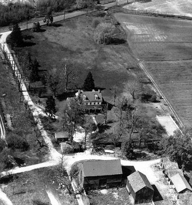
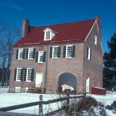
Paulsdale, Historical farm in Mount Laurel Township, New Jersey, United States.

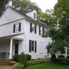
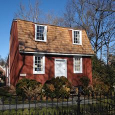
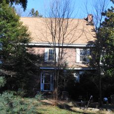
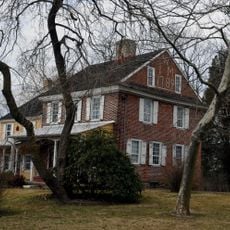
Paulsdale is a brick farmhouse in Mount Laurel Township with a two-story structure built in the 1840s, featuring a center hall and symmetrically arranged rooms. The building preserves its original architectural details and is now used by the Alice Paul Institute as a venue for exhibitions and education.

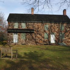
The Paul family purchased the estate in 1883 and made it a center for progressive thinking in a farming region. Alice Paul grew up here and developed the beliefs that later made her a leader in the women's suffrage movement.

The place is linked to the women's rights movement and shows how a rural family passed down their ideals across generations. Visitors see exhibitions today that document social reform and the fight for women's equality.

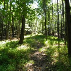
The property offers both guided tours and a self-guided outdoor audio tour that lets visitors explore at their own pace. Wear comfortable shoes since you will walk the grounds, and be prepared for weather changes as some areas may be affected by rain or sun exposure.

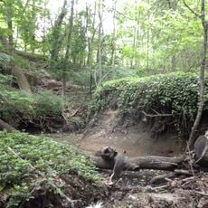
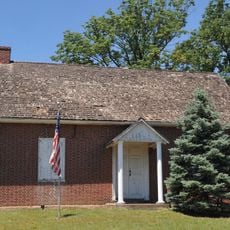
The grounds span over 100 acres of agricultural land that still reflects the original farming structure of the region. The marked stations of the audio guide draw attention to this agricultural heritage and show how daily life unfolded here more than a century ago.

The community of curious travelers

AroundUs brings together thousands of curated places, local tips, and hidden gems, enriched daily by 60,000 contributors worldwide.

Start exploring
Location
GPS coordinates
39.95670,-74.93070
Latest update
December 10, 2025 20:09
Around this place
The Funplex
United States of America

The Funplex

3.5 km
United States of America

Rancocas Creek

7.4 km
Hadrosaurus Foulkii Leidy Site
United States of America

Hadrosaurus Foulkii Leidy Site

9.8 km
Rancocas State Park
United States of America

Rancocas State Park

7.4 km
Temple Beth Sholom
United States of America

Temple Beth Sholom

9.3 km
Philadelphia Watch Case Company Building
United States of America

Philadelphia Watch Case Company Building

9.6 km
Breidenhart
United States of America

Breidenhart

1.4 km
Our Lady of Good Counsel Church
United States of America

Our Lady of Good Counsel Church

1.6 km
Barclay Farm House
United States of America

Barclay Farm House

8.1 km
Scarborough Bridge
United States of America

Scarborough Bridge

8.2 km
Evesham Friends Meeting House
United States of America

Evesham Friends Meeting House

4.1 km
Perkins Center for the Arts
United States of America

Perkins Center for the Arts

2.4 km
Springdale Farms
United States of America

Springdale Farms

8 km
Smith Mansion
United States of America

Smith Mansion

1.6 km
Burrough-Dover House
United States of America

Burrough-Dover House

7.7 km
Samuel Mickle House
United States of America

Samuel Mickle House

10.4 km
Riverside–Delanco Bridge
United States of America

Riverside–Delanco Bridge

10 km
Cropwell Friends Meeting House
United States of America

Cropwell Friends Meeting House

7.1 km
Haddon Fortnightly Club House
United States of America

Haddon Fortnightly Club House

10.5 km
MOM'S Organic Market
United States of America

MOM'S Organic Market

8.1 km
Moorestown Friends School and Meetinghouse
United States of America

Moorestown Friends School and Meetinghouse

1.2 km
Samuel Coles House
United States of America

Samuel Coles House

6.3 km
Gatehouse at Colestown Cemetery
United States of America

Gatehouse at Colestown Cemetery

5.7 km
Stokes-Evans House
United States of America

Stokes-Evans House

7.4 km
John Inskeep Homestead
United States of America

John Inskeep Homestead

6.7 km
Jacob Wills House
United States of America

Jacob Wills House

9 km
Coopertown Meetinghouse
United States of America

Coopertown Meetinghouse

10.5 km
Riverton Historic District
United States of America

Riverton Historic District

9.2 km
Show the full map
Reviews
Share your experience

No review yet

Discussions
Start a discussion...

No discussion yet

« Paulsdale - Historical farm in Mount Laurel Township, New Jersey, United States » is provided by Around Us (aroundus.com). Images and texts are derived from Wikimedia project under a Creative Commons license. You are allowed to copy, distribute, and modify copies of this page, under the conditions set by the license, as long as this note is clearly visible.

Discover hidden gems everywhere you go!

From secret cafés to breathtaking viewpoints, skip the crowded tourist spots and find places that match your style. Our app makes it easy with voice search, smart filtering, route optimization, and insider tips from travelers worldwide. Download now for the complete mobile experience.

Around Us App Screenshot

A unique approach to discovering new places

Le Figaro

All the places worth exploring

France Info

A tailor-made excursion in just a few clicks

20 Minutes

Around Us
Travel Guide & Maps
Download

Send to your phone

QR Code
1

Open the camera app on your mobile.

2

Point at the QR code with your camera. A notification will appear.

3

Tap the notification to open the link.