Enable Location

We need your location to show you interesting places around you

Discover nearby places

Find interesting locations and hidden gems around you

Precise directions

Get accurate directions and distances to places

Your location is never shared with other users. It's only used when you tap the location button.

Stuyvesant Light

Log in to your account

Start exploring — it's free

Trusted by 62,284 travelers worldwide

Continue with Google
Continue with Apple
or

We will send you a code to connect

By continuing, you accept our Terms and Conditions and our Privacy Policy

Check your inbox

We've sent a pincode in your inbox. Please enter the code below.

Stuyvesant Light

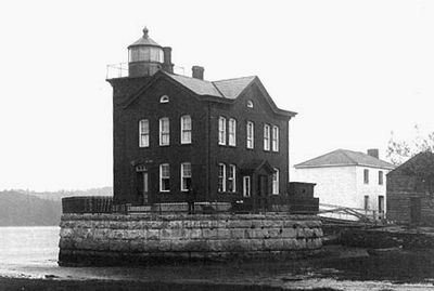
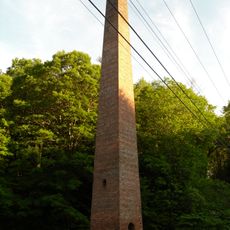
Stuyvesant Light, Lighthouse in Columbia County, US

Stuyvesant Light is a brick tower with a lantern room at its peak, positioned along the eastern bank of the Hudson River in Columbia County. The structure remains accessible for viewing from multiple angles along the riverbank and nearby paths.

The federal government funded construction in 1828 to aid river navigation and protect vessels traveling the Hudson. In 1902, ice damage destroyed the original structure, prompting the construction of the replacement that stands to this day.

The structure marks a connection to the riverfront life that once defined the region, visible to anyone walking along the water's edge or traveling by boat. Local knowledge treats it as a landmark for understanding how water transport shaped settlement patterns here.

The lighthouse is viewable throughout the year from multiple vantage points along the riverbank, making it accessible for photography at almost any time. Visitors should wear sturdy footwear if exploring the shoreline to get closer views of the tower.

The original lighthouse fell victim to ice forces in 1902, a dramatic reminder of the harsh river winters in this region. The replacement structure that followed has endured for over a century, testament to improved engineering standards.

The community of curious travelers

AroundUs brings together thousands of curated places, local tips, and hidden gems, enriched daily by 60,000 contributors worldwide.

Start exploring
Location
Inception
1829
GPS coordinates
42.41170,-73.77830
Latest update
December 14, 2025 17:42
Around this place
Castleton Bridge
United States of America

Castleton Bridge

10.9 km
Alcove Reservoir
United States of America

Alcove Reservoir

14 km
Alfred H. Smith Memorial Bridge
United States of America

Alfred H. Smith Memorial Bridge

10.8 km
Bronck House
United States of America

Bronck House

9.7 km
Van Alen House
United States of America

Van Alen House

7.9 km
Coxsackie Light
United States of America

Coxsackie Light

3.8 km
Bethlehem House
United States of America

Bethlehem House

14.7 km
Ariaanje Coeymans House
United States of America

Ariaanje Coeymans House

7.3 km
Muitzes Kill Historic District
United States of America

Muitzes Kill Historic District

8.5 km
Bronck Farm 13-Sided Barn
United States of America

Bronck Farm 13-Sided Barn

9.1 km
Van Bergen House
United States of America

Van Bergen House

5.5 km
Kinderhook Village District
United States of America

Kinderhook Village District

6.9 km
Schodack Landing Historic District
United States of America

Schodack Landing Historic District

8 km
Church of St. John the Evangelist
United States of America

Church of St. John the Evangelist

11.8 km
Israel Shear House
United States of America

Israel Shear House

12 km
Dr. Wesley Blaisdell House
United States of America

Dr. Wesley Blaisdell House

6.8 km
Peck House
United States of America

Peck House

13.8 km
Mull House and Cemetery
United States of America

Mull House and Cemetery

10.4 km
Valley Paper Mill Chimney and Site
United States of America

Valley Paper Mill Chimney and Site

13.7 km
Coeymans School
United States of America

Coeymans School

7 km
Abraham Houghtaling House
United States of America

Abraham Houghtaling House

7.2 km
District School No. 7
United States of America

District School No. 7

12.2 km
Alcove Historic District
United States of America

Alcove Historic District

13.8 km
Bronk-Silvester House
United States of America

Bronk-Silvester House

6.5 km
New Baltimore Hamlet Historic District
United States of America

New Baltimore Hamlet Historic District

3.9 km
Reed Street Historic District
United States of America

Reed Street Historic District

6.9 km
Sunderland Center Historic District
United States of America

Sunderland Center Historic District

7.8 km
Sleepy Hollow Lake
United States of America

Sleepy Hollow Lake

13.3 km
Show the full map
« Stuyvesant Light - Lighthouse in Columbia County, US » is provided by Around Us (aroundus.com). Images and texts are derived from Wikimedia project under a Creative Commons license. You are allowed to copy, distribute, and modify copies of this page, under the conditions set by the license, as long as this note is clearly visible.

Discover hidden gems everywhere you go!

From secret cafés to breathtaking viewpoints, skip the crowded tourist spots and find places that match your style. Our app makes it easy with voice search, smart filtering, route optimization, and insider tips from travelers worldwide. Download now for the complete mobile experience.

Around Us App Screenshot

A unique approach to discovering new places

Le Figaro

All the places worth exploring

France Info

A tailor-made excursion in just a few clicks

20 Minutes

Around Us
Travel Guide & Maps
Download

Send to your phone

QR Code
1

Open the camera app on your mobile.

2

Point at the QR code with your camera. A notification will appear.

3

Tap the notification to open the link.