Enable Location

We need your location to show you interesting places around you

Discover nearby places

Find interesting locations and hidden gems around you

Precise directions

Get accurate directions and distances to places

Your location is never shared with other users. It's only used when you tap the location button.

Dorothy Lake State Natural Area

Log in to your account

Start exploring — it's free

Trusted by 63,728 travelers worldwide

Continue with Google
Continue with Apple
or

We will send you a code to connect

By continuing, you accept our Terms and Conditions and our Privacy Policy

Check your inbox

We've sent a pincode in your inbox. Please enter the code below.

Dorothy Lake State Natural Area
Discussion Reviews 1 Photos
1.5k Popularity

Dorothy Lake State Natural Area, lake of the United States of America

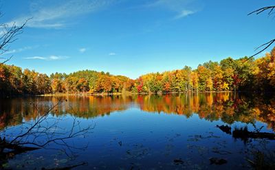
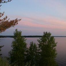
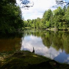
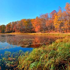
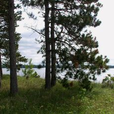
Dorothy Lake State Natural Area is a protected natural space in Wisconsin featuring a small, calm lake surrounded by forest. The landscape includes mixed woodlands, wetland areas, and terrain shaped by glaciers, covering approximately 95 acres.

The area was designated as protected in 2010 to preserve the natural landscape and rare plant species found there. It had remained wild for centuries before being formally protected to prevent development and safeguard wildlife habitat.

The name Dorothy Lake comes from the area's local history. Today, visitors use the place to walk quietly, watch birds, and experience nature away from busy surroundings.

Access is through simple walking trails that branch from Deer Fly Trail, located about nine miles west of Holcombe. The gentle terrain makes it accessible for visitors of all ages, though snow cover can change conditions during winter months.

The area is home to several rare plant species including Blunt-Lobe Grape Fern and White Adder's Mouth that do not grow elsewhere in the region. A notable feature is a boggy shoreline with unique floating moss that grows on the water surface and exists nowhere else in the area.

The community of curious travelers

AroundUs brings together thousands of curated places, local tips, and hidden gems, enriched daily by 60,000 contributors worldwide.

Start exploring
Inception
2010
GPS coordinates
45.22389,-91.30222
Latest update
February 9, 2026 08:19
Around this place
Lake Wissota
United States of America

Lake Wissota

30.9 km
Brunet Island State Park
United States of America

Brunet Island State Park

11.8 km
James Sheeley House
United States of America

James Sheeley House

33.2 km
Cornell Pulpwood Stacker
United States of America

Cornell Pulpwood Stacker

12.8 km
Z. C. B. J. Hall
United States of America

Z. C. B. J. Hall

24 km
Sacred Heart Church
United States of America

Sacred Heart Church

47.8 km
Edward N. and Mary T. Stebbins House
United States of America

Edward N. and Mary T. Stebbins House

47.6 km
Flambeau Mission Church
United States of America

Flambeau Mission Church

11.9 km
Cook-Rutledge House
United States of America

Cook-Rutledge House

33.3 km
Saint Edward's Chapel
United States of America

Saint Edward's Chapel

47.7 km
Colfax Municipal Building
United States of America

Colfax Municipal Building

41.6 km
Emery Street Bungalow District
United States of America

Emery Street Bungalow District

48.1 km
John Bohrnstedt House
United States of America

John Bohrnstedt House

42.2 km
St. Joseph's Chapel
United States of America

St. Joseph's Chapel

46.7 km
Jump River Town Hall
United States of America

Jump River Town Hall

41.6 km
D. R. Moon Memorial Library
United States of America

D. R. Moon Memorial Library

41 km
Children’s Museum of Eau Claire
United States of America

Children’s Museum of Eau Claire

48.2 km
West Hill Residential Historic District
United States of America

West Hill Residential Historic District

33.2 km
L.I. Roe House
United States of America

L.I. Roe House

41.1 km
Chippewa Moraine Lakes State Natural Area
United States of America

Chippewa Moraine Lakes State Natural Area

3.8 km
Drummond Business Block
United States of America

Drummond Business Block

48.1 km
Rice Lake station
United States of America

Rice Lake station

46.4 km
Bridge Street Commercial Historic District
United States of America

Bridge Street Commercial Historic District

32.8 km
Lake Wissota State Park
United States of America

Lake Wissota State Park

28.3 km
Pioneer Village Museum
United States of America

Pioneer Village Museum

41.9 km
Notre Dame Church and Goldsmith Memorial Chapel
United States of America

Notre Dame Church and Goldsmith Memorial Chapel

32.7 km
Lutheran Church of the Good Shepherd
United States of America

Lutheran Church of the Good Shepherd

48.1 km
Marsh Rainbow Arch Bridge
United States of America

Marsh Rainbow Arch Bridge

32.7 km
Show the full map
Reviews
Share your experience

No review yet

Discussions
Start a discussion...

No discussion yet

« Dorothy Lake State Natural Area - lake of the United States of America » is provided by Around Us (aroundus.com). Images and texts are derived from Wikimedia project under a Creative Commons license. You are allowed to copy, distribute, and modify copies of this page, under the conditions set by the license, as long as this note is clearly visible.

Discover hidden gems everywhere you go!

From secret cafés to breathtaking viewpoints, skip the crowded tourist spots and find places that match your style. Our app makes it easy with voice search, smart filtering, route optimization, and insider tips from travelers worldwide. Download now for the complete mobile experience.

Around Us App Screenshot

A unique approach to discovering new places

Le Figaro

All the places worth exploring

France Info

A tailor-made excursion in just a few clicks

20 Minutes

Around Us
Travel Guide & Maps
Download

Send to your phone

QR Code
1

Open the camera app on your mobile.

2

Point at the QR code with your camera. A notification will appear.

3

Tap the notification to open the link.