Enable Location

We need your location to show you interesting places around you

Discover nearby places

Find interesting locations and hidden gems around you

Precise directions

Get accurate directions and distances to places

Your location is never shared with other users. It's only used when you tap the location button.

Brunet Island State Park

Log in to your account

Start exploring — it's free

Trusted by 62,068 travelers worldwide

Continue with Google
Continue with Apple
or

We will send you a code to connect

By continuing, you accept our Terms and Conditions and our Privacy Policy

Check your inbox

We've sent a pincode in your inbox. Please enter the code below.

Brunet Island State Park

Brunet Island State Park, State park at Chippewa River, Wisconsin, US.

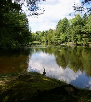
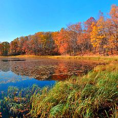
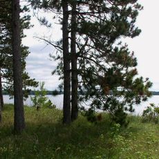
Brunet Island State Park is a 1,225-acre woodland preserve along the Chippewa River in Wisconsin that encompasses a 169-acre island and mainland parcels. The terrain features hemlock forests, river channels, and the confluence where two waterways meet.

The area was a logging hub during the 1800s before Northern States Power donated the land in 1936. The Civilian Conservation Corps constructed a log building in 1938, and the park welcomed its first visitors in 1940.

The park takes its name from Jean Brunet, a French settler who shaped the upper Chippewa region through dam and mill construction during the logging era. His influence remains visible in the forests that grew back after industrial activity ended.

The park operates two campgrounds with a total of 69 sites spread across north and south sections. Hiking trails thread through forests and along riverbanks, offering routes suitable for different fitness levels.

A tornado in 1977 leveled about 18 acres in the northern section, creating an accidental natural experiment. The birch trees that grew back there reveal how forest ecosystems recover after major disturbance.

The community of curious travelers

AroundUs brings together thousands of curated places, local tips, and hidden gems, enriched daily by 60,000 contributors worldwide.

Start exploring
Location
Inception
1936
GPS coordinates
45.17920,-91.16640
Latest update
December 6, 2025 17:43
Hidden gems in Wisconsin : caves, islands, gorges

Wisconsin contains numerous natural areas and historic sites away from typical tourist routes. Geological features include Cave of the Mounds with limestone formations, Parfrey's Glen with an 800-foot gorge, and Pewit's Nest State Natural Area with sandstone cliffs. The Apostle Islands Ice Caves...

Around this place
Lake Wissota
United States of America

Lake Wissota

28.8 km
James Sheeley House
United States of America

James Sheeley House

32.7 km
Cornell Pulpwood Stacker
United States of America

Cornell Pulpwood Stacker

1 km
State Theatre
United States of America

State Theatre

48.6 km
Z. C. B. J. Hall
United States of America

Z. C. B. J. Hall

15.7 km
Sacred Heart Church
United States of America

Sacred Heart Church

48 km
Flambeau Mission Church
United States of America

Flambeau Mission Church

13.9 km
Cook-Rutledge House
United States of America

Cook-Rutledge House

33 km
Saint Edward's Chapel
United States of America

Saint Edward's Chapel

47.8 km
Colfax Municipal Building
United States of America

Colfax Municipal Building

48.4 km
Emery Street Bungalow District
United States of America

Emery Street Bungalow District

47.8 km
John Bohrnstedt House
United States of America

John Bohrnstedt House

40 km
St. Joseph's Chapel
United States of America

St. Joseph's Chapel

46.6 km
Eau Claire Public Library
United States of America

Eau Claire Public Library

48.5 km
Jump River Town Hall
United States of America

Jump River Town Hall

34.4 km
D. R. Moon Memorial Library
United States of America

D. R. Moon Memorial Library

30.2 km
Children’s Museum of Eau Claire
United States of America

Children’s Museum of Eau Claire

48.4 km
West Hill Residential Historic District
United States of America

West Hill Residential Historic District

33.1 km
L.I. Roe House
United States of America

L.I. Roe House

30.3 km
Chippewa Moraine Lakes State Natural Area
United States of America

Chippewa Moraine Lakes State Natural Area

15 km
Drummond Business Block
United States of America

Drummond Business Block

48.4 km
Barnes Block
United States of America

Barnes Block

48.6 km
Einar and Alice Borton House
United States of America

Einar and Alice Borton House

48.1 km
Bridge Street Commercial Historic District
United States of America

Bridge Street Commercial Historic District

32.3 km
Lake Wissota State Park
United States of America

Lake Wissota State Park

25.5 km
Notre Dame Church and Goldsmith Memorial Chapel
United States of America

Notre Dame Church and Goldsmith Memorial Chapel

32.2 km
Jane E. Putnam Memorial Chapel
United States of America

Jane E. Putnam Memorial Chapel

48.4 km
Marsh Rainbow Arch Bridge
United States of America

Marsh Rainbow Arch Bridge

32.3 km
Show the full map
« Brunet Island State Park - State park at Chippewa River, Wisconsin, US » is provided by Around Us (aroundus.com). Images and texts are derived from Wikimedia project under a Creative Commons license. You are allowed to copy, distribute, and modify copies of this page, under the conditions set by the license, as long as this note is clearly visible.

Discover hidden gems everywhere you go!

From secret cafés to breathtaking viewpoints, skip the crowded tourist spots and find places that match your style. Our app makes it easy with voice search, smart filtering, route optimization, and insider tips from travelers worldwide. Download now for the complete mobile experience.

Around Us App Screenshot

A unique approach to discovering new places

Le Figaro

All the places worth exploring

France Info

A tailor-made excursion in just a few clicks

20 Minutes

Around Us
Travel Guide & Maps
Download

Send to your phone

QR Code
1

Open the camera app on your mobile.

2

Point at the QR code with your camera. A notification will appear.

3

Tap the notification to open the link.