Enable Location

We need your location to show you interesting places around you

Discover nearby places

Find interesting locations and hidden gems around you

Precise directions

Get accurate directions and distances to places

Your location is never shared with other users. It's only used when you tap the location button.

Log in to your account

Start exploring — it's free

Trusted by 62,447 travelers worldwide

Continue with Google
Continue with Apple
or

We will send you a code to connect

By continuing, you accept our Terms and Conditions and our Privacy Policy

Check your inbox

We've sent a pincode in your inbox. Please enter the code below.

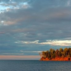
Kakagon Sloughs, Protected wetland in Wisconsin, United States.

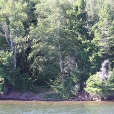
Kakagon Sloughs is an extensive wetland system in northern Wisconsin near Lake Superior, featuring interconnected waterways, marshes, and streams across a varied landscape. The area contains substantial wild rice beds and provides multiple access points along the shoreline for visitors to explore.

Indigenous peoples settled in this area thousands of years ago, drawing on the abundant natural resources for food and survival. This long relationship with the wetlands established patterns of use that continue to shape the place today.

The Anishinabe peoples maintain a direct connection to these waters through traditional wild rice harvesting that remains an active part of their cultural life today. This practice shapes how the wetlands are used and perceived by those who visit and work there.

Visit during the warmer months from spring through fall when conditions are ideal for exploration and guided kayak tours are available. Multiple access points along the shoreline allow you to choose where to begin your visit based on your interests.

This wetland contains one of the largest remaining concentrations of wild rice beds in the Great Lakes region. This abundance of wild rice is unusual and makes the ecosystem particularly valuable for both wildlife and traditional harvesting.

The community of curious travelers

AroundUs brings together thousands of curated places, local tips, and hidden gems, enriched daily by 60,000 contributors worldwide.

Start exploring
Location
GPS coordinates
46.66220,-90.74100
Latest update
December 9, 2025 20:21
Around this place
Big Bay State Park
United States of America

Big Bay State Park

16.2 km
Ashland Harbor Breakwater Light
United States of America

Ashland Harbor Breakwater Light

10.6 km
Whittlesey Creek National Wildlife Refuge
United States of America

Whittlesey Creek National Wildlife Refuge

18.6 km
La Pointe Light
United States of America

La Pointe Light

8.1 km
Madeline Island Historical Museum
United States of America

Madeline Island Historical Museum

13.7 km
Bass Island Brownstone Company Quarry
United States of America

Bass Island Brownstone Company Quarry

19 km
Chequamegon Point Light
United States of America

Chequamegon Point Light

9 km
Frank Boutin, Jr. House
United States of America

Frank Boutin, Jr. House

17.8 km
Bayfield Fish Hatchery
United States of America

Bayfield Fish Hatchery

16.7 km
Christ Episcopal Church
United States of America

Christ Episcopal Church

17.8 km
Ellis School
United States of America

Ellis School

12.7 km
Bayfield County Courthouse
United States of America

Bayfield County Courthouse

11.7 km
City of Ashland
United States of America

City of Ashland

6.9 km
Security Savings Bank
United States of America

Security Savings Bank

13.6 km
Beaser School
United States of America

Beaser School

14.8 km
Ashland County Courthouse
United States of America

Ashland County Courthouse

13.6 km
Grand Opera House
United States of America

Grand Opera House

13.6 km
Chapple and MacArthur Avenues Residential Historic District
United States of America

Chapple and MacArthur Avenues Residential Historic District

14.2 km
West Second Street Historic District
United States of America

West Second Street Historic District

13.7 km
Wilmarth School
United States of America

Wilmarth School

13.8 km
Washburn Public Library
United States of America

Washburn Public Library

11.8 km
Wakefield Hall
United States of America

Wakefield Hall

13.6 km
East Third Street Residential Historic District
United States of America

East Third Street Residential Historic District

11.4 km
Bayfield Historic District
United States of America

Bayfield Historic District

17.5 km
Ashland Bay Cinema
United States of America

Ashland Bay Cinema

13.8 km
Madeline Island
United States of America

Madeline Island

13.6 km
Madeline Island Public Library
United States of America

Madeline Island Public Library

13.8 km
Vaughn Public Library
United States of America

Vaughn Public Library

13.9 km
Show the full map
« Kakagon Sloughs - Protected wetland in Wisconsin, United States » is provided by Around Us (aroundus.com). Images and texts are derived from Wikimedia project under a Creative Commons license. You are allowed to copy, distribute, and modify copies of this page, under the conditions set by the license, as long as this note is clearly visible.

Discover hidden gems everywhere you go!

From secret cafés to breathtaking viewpoints, skip the crowded tourist spots and find places that match your style. Our app makes it easy with voice search, smart filtering, route optimization, and insider tips from travelers worldwide. Download now for the complete mobile experience.

Around Us App Screenshot

A unique approach to discovering new places

Le Figaro

All the places worth exploring

France Info

A tailor-made excursion in just a few clicks

20 Minutes

Around Us
Travel Guide & Maps
Download

Send to your phone

QR Code
1

Open the camera app on your mobile.

2

Point at the QR code with your camera. A notification will appear.

3

Tap the notification to open the link.