Enable Location

We need your location to show you interesting places around you

Discover nearby places

Find interesting locations and hidden gems around you

Precise directions

Get accurate directions and distances to places

Your location is never shared with other users. It's only used when you tap the location button.

Log in to your account

Start exploring — it's free

Trusted by 67,495 travelers worldwide

Continue with Google
Continue with Apple
or

We will send you a code to connect

By continuing, you accept our Terms and Conditions and our Privacy Policy

Check your inbox

We've sent a pincode in your inbox. Please enter the code below.

Rainbow Lake Wilderness
Discussion Reviews Photo
1.6k Popularity

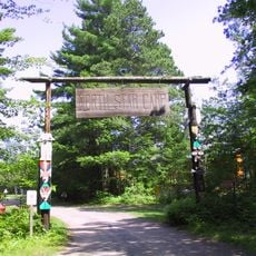
Rainbow Lake Wilderness, Wilderness area in Bayfield County, Wisconsin, US

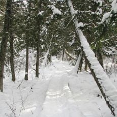
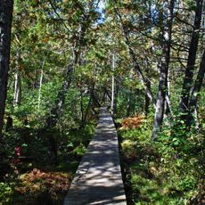
Rainbow Lake Wilderness is a protected forest area in Chequamegon National Forest in northern Wisconsin, covering about 7,135 acres (2,890 hectares). The area contains one main lake, many smaller lakes and ponds, all surrounded by dense mixed forest of hardwoods and conifers.

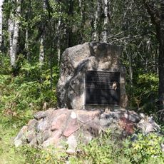
This area was established as a protected wilderness in 1975 to conserve the natural environment of northern Wisconsin. The land had previously been subject to commercial logging before it received official protection.

The North Country National Scenic Trail passes through this area and follows old paths that connect visitors to the forest's past. These routes show how people once used the forest for timber harvesting.

Forest Service roads provide access points for hiking, fishing, and camping around the wilderness area. Visitors should come prepared for rugged terrain and variable weather conditions typical of northern forests.

The area contains a mix of tree types, including balsam fir, paper birch, and pine, that form different forest types. This varied forest structure creates habitats for black bears, bald eagles, and red foxes.

The community of curious travelers

AroundUs brings together thousands of curated places, local tips, and hidden gems, enriched daily by 60,000 contributors worldwide.

Start exploring
GPS coordinates
46.41790,-91.30141
Latest update
December 14, 2025 14:22
Around this place
National Fresh Water Fishing Hall of Fame
United States of America

National Fresh Water Fishing Hall of Fame

47.7 km
Brule River State Forest
United States of America

Brule River State Forest

25.8 km
Ashland Harbor Breakwater Light
United States of America

Ashland Harbor Breakwater Light

40.5 km
Whittlesey Creek National Wildlife Refuge
United States of America

Whittlesey Creek National Wildlife Refuge

32.4 km
Moquah Barrens Research Natural Area
United States of America

Moquah Barrens Research Natural Area

23.5 km
Lake Hayward
United States of America

Lake Hayward

47.6 km
Park Theater
United States of America

Park Theater

47.8 km
Brule Glacial Spillway State Natural Area
United States of America

Brule Glacial Spillway State Natural Area

32.5 km
Ellis School
United States of America

Ellis School

38.2 km
Bayfield County Courthouse
United States of America

Bayfield County Courthouse

42.6 km
City of Ashland
United States of America

City of Ashland

47 km
Security Savings Bank
United States of America

Security Savings Bank

37.2 km
Beaser School
United States of America

Beaser School

36.1 km
Ashland County Courthouse
United States of America

Ashland County Courthouse

37.2 km
Chapple and MacArthur Avenues Residential Historic District
United States of America

Chapple and MacArthur Avenues Residential Historic District

36.7 km
Grand Opera House
United States of America

Grand Opera House

37.2 km
West Second Street Historic District
United States of America

West Second Street Historic District

37.1 km
Forest Lodge Library
United States of America

Forest Lodge Library

23.4 km
Wilmarth School
United States of America

Wilmarth School

37.2 km
Washburn Public Library
United States of America

Washburn Public Library

42.1 km
Wakefield Hall
United States of America

Wakefield Hall

37.4 km
Freshwater Fishing Hall of Fame
United States of America

Freshwater Fishing Hall of Fame

47.6 km
Herbster Community Center
United States of America

Herbster Community Center

46.1 km
East Third Street Residential Historic District
United States of America

East Third Street Residential Historic District

42.6 km
Maslowski Beach East
United States of America

Maslowski Beach East

34.7 km
Scheer's Lumberjack Shows
United States of America

Scheer's Lumberjack Shows

47.8 km
North Star Camp For Boys
United States of America

North Star Camp For Boys

37.2 km
Ashland Bay Cinema
United States of America

Ashland Bay Cinema

37 km
Show the full map
Reviews
Share your experience

No review yet

Discussions
Start a discussion...

No discussion yet

« Rainbow Lake Wilderness - Wilderness area in Bayfield County, Wisconsin, US » is provided by Around Us (aroundus.com). Images and texts are derived from Wikimedia project under a Creative Commons license. You are allowed to copy, distribute, and modify copies of this page, under the conditions set by the license, as long as this note is clearly visible.

Discover hidden gems everywhere you go!

From secret cafés to breathtaking viewpoints, skip the crowded tourist spots and find places that match your style. Our app makes it easy with voice search, smart filtering, route optimization, and insider tips from travelers worldwide. Download now for the complete mobile experience.

Around Us App Screenshot

A unique approach to discovering new places

Le Figaro

All the places worth exploring

France Info

A tailor-made excursion in just a few clicks

20 Minutes

Around Us
Travel Guide & Maps
Download

Send to your phone

QR Code
1

Open the camera app on your mobile.

2

Point at the QR code with your camera. A notification will appear.

3

Tap the notification to open the link.