Chest opened
+${chestReward.xp} XP
Explorer
NOUVEAU ×${chestReward.collectible.quantity}
tapez pour fermer
Chest locked

Open chests in the app

Around Us is built for your phone — chests unlock when you walk, explore and capture nearby places.

Enable Location

We need your location to show you interesting places around you

Discover nearby places

Find interesting locations and hidden gems around you

Precise directions

Get accurate directions and distances to places

Your location is never shared with other users. It's only used when you tap the location button.

Log in to your account

Start exploring — it's free

Trusted by 72,881 travelers worldwide

Continue with Google
Continue with Apple
or

We will send you a code to connect

By continuing, you accept our Terms and Conditions and our Privacy Policy

Check your inbox

We've sent a pincode in your inbox. Please enter the code below.

Young Brothers Massacre
Discussion Reviews Photo
14.6k Popularity

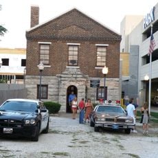
Young Brothers Massacre, Law enforcement tragedy site near Brookline, Missouri.

The Young Brothers Massacre refers to a deadly confrontation between law enforcement and two criminals at a farmhouse location in Greene County. Six officers died during an arrest attempt in January 1932.

The incident occurred in 1932 when officers attempted to arrest two brothers involved in auto theft operations. It represented the highest number of law enforcement casualties in a single confrontation until another tragedy surpassed it many decades later.

The event left a mark on how law enforcement approached dangerous situations and became a reference point in discussions about police safety. Memorials throughout the county keep the memory of those who died alive in the community.

The site is marked by several memorials and historical plaques located throughout Greene County. Visitors can explore these locations by following local markers and directions, with materials available at county offices and police headquarters.

What often goes unnoticed is that the confrontation highlighted gaps in police training and response procedures of that era. The incident prompted significant changes in how law enforcement prepared officers for armed encounters.

The community of curious travelers

AroundUs brings together thousands of curated places, local tips, and hidden gems, enriched daily by 60,000 contributors worldwide.

Start exploring
Location
GPS coordinates
37.18543,-93.39254
Latest update
December 7, 2025 20:21
Around this place
Wonders of Wildlife Museum & Aquarium
United States of America

Wonders of Wildlife Museum & Aquarium

8.5 km
Heer's Department Store
United States of America

Heer's Department Store

9.2 km
Old Calaboose
United States of America

Old Calaboose

9.1 km
Day House
United States of America

Day House

9.1 km
Palace Hotel
United States of America

Palace Hotel

9.1 km
United States of America

Springfield Grocer Company Warehouse

9.2 km
Springfield Seed Co. Office and Warehouse
United States of America

Springfield Seed Co. Office and Warehouse

9 km
J.E. King Manufacturing Company
United States of America

J.E. King Manufacturing Company

8.5 km
United States of America

South Avenue Commercial Historic District

9.2 km
Robert B. and Vitae A. Kite Apartment Building
United States of America

Robert B. and Vitae A. Kite Apartment Building

9 km
United States of America

Rock Fountain Court Historic District

6.6 km
United States of America

Campbell Avenue Historic District

9.1 km
Fallin Brothers Building
United States of America

Fallin Brothers Building

9 km
Finkbiner Building
United States of America

Finkbiner Building

9 km
Henry Schneider Building
United States of America

Henry Schneider Building

8.9 km
United States of America

St. Paul Block

9.2 km
United States of America

West Walnut Street Commercial Historic District

9.1 km
United States of America

South-McDaniel-Patton Commercial Historic District

9.2 km
Wilson's Creek National Battlefield Visitor Center
United States of America

Wilson's Creek National Battlefield Visitor Center

8.1 km
United States of America

Lyric Theatre

9 km
United States of America

Horton Smith Municipal Golf Course

5.2 km
United States of America

Deer Lake Golf Course

2.7 km
United States of America

Deer Lake Golf Course

2.1 km
United States of America

Randy Bacon Photography

8.8 km
United States of America

World's Largest Fork

7.6 km
United States of America

Route of Union Advance & Withdrawal (West Overlook)

8.5 km
United States of America

Pulaski Arkansas Battery

9.2 km
United States of America

Bloody Hill

9.1 km
Show the full map
Reviews
Share your experience

No review yet

Discussions
Start a discussion...

No discussion yet

« Young Brothers Massacre - Law enforcement tragedy site near Brookline, Missouri » is provided by Around Us (aroundus.com). Images and texts are derived from Wikimedia project under a Creative Commons license. You are allowed to copy, distribute, and modify copies of this page, under the conditions set by the license, as long as this note is clearly visible.

Discover hidden gems everywhere you go!

From secret cafés to breathtaking viewpoints, skip the crowded tourist spots and find places that match your style. Our app makes it easy with voice search, smart filtering, route optimization, and insider tips from travelers worldwide. Download now for the complete mobile experience.

Around Us App Screenshot

A unique approach to discovering new places

Le Figaro

All the places worth exploring

France Info

A tailor-made excursion in just a few clicks

20 Minutes

Around Us
Travel Guide & Maps
Download

Send to your phone

QR Code
1

Open the camera app on your mobile.

2

Point at the QR code with your camera. A notification will appear.

3

Tap the notification to open the link.