Tiến Thành, Landgemeinde in Vietnam
Location: Phan Thiết
Elevation above the sea: 57 m
GPS coordinates: 10.84583,108.03417
Latest update: November 14, 2025 19:45

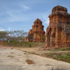
Thap Po Sah Inu temple
15.8 km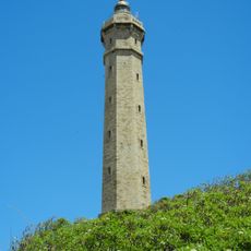
Kê Gà Lighthouse
17.4 km
Biggest sleeping Buddha in Vietnam
15.6 km
Tượng Bác Hồ và các cháu
11.4 km
Bikini Beach
1.4 km
Sand Painting
13.9 km
TDC Phan Thiết
9.1 km
Đường ra Kê Gà
16.6 km
Nhà dì Loan
11.9 km
Work of art
9.1 km
Mũi Kê Gà
16.9 km
Fishing Boats
15.2 km
Lầu Ông Hoàng
15.6 km
Tháp Po Sah Inư
15.8 km
Turt to Lighttower
16.4 km
Po Sah Inu Cham Towers
15.9 km
Monument
14.3 km
Tháp nước Phan Thiết
11.7 km
Bảo tàng Hồ Chí Minh
11.4 km
Tượng đài Chiến Thắng
12.1 km
Monument
16.8 km
Memorial
9.6 km
Memorial
13.2 km
Tượng đài Việt Quốc Công
12.8 km
Tượng Phật Bà
11 km
Tượng chiến sĩ cách mạng
12.4 km
Bia tưởng niệm
12.1 km
Memorial, war memorial
15.7 kmReviews
Visited this place? Tap the stars to rate it and share your experience / photos with the community! Try now! You can cancel it anytime.
Discover hidden gems everywhere you go!
From secret cafés to breathtaking viewpoints, skip the crowded tourist spots and find places that match your style. Our app makes it easy with voice search, smart filtering, route optimization, and insider tips from travelers worldwide. Download now for the complete mobile experience.

A unique approach to discovering new places❞
— Le Figaro
All the places worth exploring❞
— France Info
A tailor-made excursion in just a few clicks❞
— 20 Minutes