Gunboat Harbour Conservancy, protected area in British Columbia, Canada
Location: North Coast Regional District
GPS coordinates: 53.92056,-130.13750
Latest update: November 22, 2025 14:05
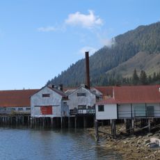
North Pacific Cannery National Historic Site
31 km
Prudhomme Lake Provincial Park
35.7 km
Frizzell Hotsprings
35.8 km
Diana Lake Provincial Park
34.3 km
Kitson Island Marine Provincial Park
31.1 km
Klewnuggit Inlet Marine Provincial Park
38.8 km
Gamble Creek Ecological Reserve
32.6 km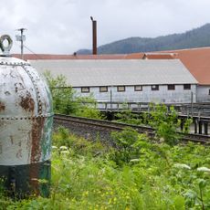
North Pacific Cannery National Historic Site
31 km
Holland Rock Light
31.6 km
Pa-aat Conservancy
19.6 km
Ecstall-Sparkling Conservancy
24.9 km
Skeena Bank Conservancy
34.7 km
Marked Tree Bluff
16.6 km
Raspberry Bluff
31.9 km
Ecstall-Spokskuut Conservancy
22.7 km
Purple Cliff
37.2 km
Skeena River
24.3 km
Gitxaala Nii Luutiksm/Kitkatla Conservancy
30.1 km
Work of art
35.4 km
Work of art
38.2 km
Scenic viewpoint
34.6 km
Scenic viewpoint
36.4 km
Scenic viewpoint
31.9 km
Diana Falls Viewpoint
33.7 km
Ruins, scenic viewpoint
30.3 km
Andy's Pad
34 km
Diana Falls
33.6 km
Waterfall
34.4 kmReviews
Visited this place? Tap the stars to rate it and share your experience / photos with the community! Try now! You can cancel it anytime.
Discover hidden gems everywhere you go!
From secret cafés to breathtaking viewpoints, skip the crowded tourist spots and find places that match your style. Our app makes it easy with voice search, smart filtering, route optimization, and insider tips from travelers worldwide. Download now for the complete mobile experience.

A unique approach to discovering new places❞
— Le Figaro
All the places worth exploring❞
— France Info
A tailor-made excursion in just a few clicks❞
— 20 Minutes