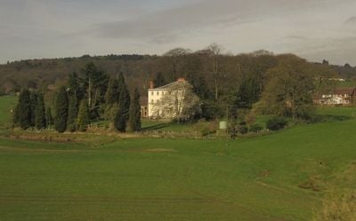
Cofton Hall, Grade II* listed building in Cofton Hackett, England.
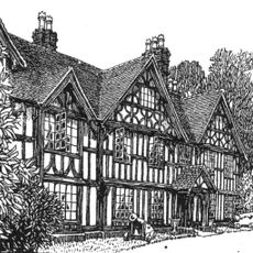
Cofton Hall is a three-story stone building in Cofton Hackett with six bays, a tiled roof, and an entrance portico supported by two Doric columns. The structure combines medieval timber framing with Victorian stonework and features extensive underground passages and chambers with brick channels for natural temperature control.
The building originates from the 14th century as a medieval hall before later Victorian additions reshaped its appearance. During the English Civil War in 1645, it was destroyed by fire to prevent its capture by opposing forces.
The medieval great hall displays intricate timber work with nine hammer-beams and wooden corbels that reflect English craftsmanship traditions. Visitors walking through this space can observe these details firsthand and appreciate the care taken by historical artisans.
The building is accessible by footpaths and offers limited access options due to its historical construction. Visitors should expect uneven surfaces and tight spaces in underground areas.
The underground passages contain brick channels that served as natural cooling for multiple chambers and represented an innovative concept for its era. This temperature-control system reveals early techniques for environmental engineering in historical structures.
The community of curious travelers
AroundUs brings together thousands of curated places, local tips, and hidden gems, enriched daily by 60,000 contributors worldwide.