Cadson Bury, Archaeological site in St Ive and Pensilva, England
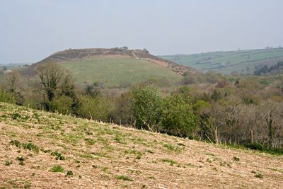
Cadson Bury is a prehistoric hill fort in Cornwall with defensive banks that enclose a level interior area. Multiple entrance points on different sides suggest the site served an important function in protecting inhabitants or gatherings at this elevated location.
The structure dates to prehistoric times, though it was first recorded on a map during the 18th century. This suggests the original fortification served its purpose centuries before being documented by mapmakers.
The monument contains archaeological artifacts, including a spindle whorl discovered on the southeastern slope, providing evidence of early settlement activities.
The site sits on a hill and is accessible via footpaths from the surrounding countryside. Visitors should be prepared for uneven ground and changing weather conditions that occur at elevated locations.
Artifacts like spinning tools have been found on the hillside slopes, revealing that people engaged in everyday work here beyond just defensive purposes. These discoveries help researchers understand how daily life unfolded at this early settlement.
Location: St Ive and Pensilva
GPS coordinates: 50.48279,-4.33657
Latest update: December 13, 2025 12:23
Dupath Well
3.9 km
Church of St Ivo
3.4 km
St Mary's Church, Callington
2.7 km
Church of St Odulphus
3.9 km
Butchers Arms
3.3 km
Guide Post At South West Corner Of Cobbledicks Cottage
715 m
Milestone, 100 Metres North Of Junction Of A390 With B3255
1.9 km
Guidepost 250 Metres North Of Keason
2.6 km
Clapper Bridge
2.3 km
Milestone To The North Of No. 128
3.7 km
Milestone 250 Metres North West Of West Haye Farmhouse
2.7 km
Callington War Memorial
2.7 km
Milestone 250 Metres North Of Keason
2.6 km
Milestone 300 Metres To West Of Chantry St Ive
3.6 km
Milestone At Sx 376 681
3.5 km
Milestone At North East Junctions Of A390 And Frogwell Road
761 m
Milestone 300 Metres To South East Of Junction A388 With B3255
2.8 km
Take-Off Stone 200 Metres To North Of Cadson
650 m
Put-On Stone 60 Metres To East Of Coombegate
2.2 km
Milestone 500 Metres To North West To Cadson
1 km
Borough Stone 10 Metres East Of Chyvarhas Residential Home
2.7 km
Milestone Opposite Gang Cottage
3.5 km
Milestone At Bramble Wood
2.3 km
Milestone 400M South Of Rill Farm
1.8 km
Newbridge
736 m
Cornelly
3.3 km
Newton Ferrers House
1.5 km
Milestone, Westcott Lodge
3.5 kmVisited this place? Tap the stars to rate it and share your experience / photos with the community! Try now! You can cancel it anytime.
Discover hidden gems everywhere you go!
From secret cafés to breathtaking viewpoints, skip the crowded tourist spots and find places that match your style. Our app makes it easy with voice search, smart filtering, route optimization, and insider tips from travelers worldwide. Download now for the complete mobile experience.
A unique approach to discovering new places❞
— Le Figaro
All the places worth exploring❞
— France Info
A tailor-made excursion in just a few clicks❞
— 20 Minutes