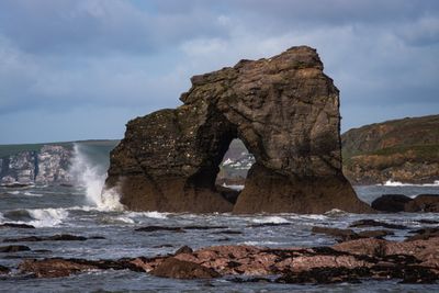
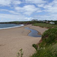
Thurlestone Rock, Limestone reef near Thurlestone, England
Thurlestone Rock is a limestone reef formation with two connected stone stacks rising prominently from the water. The structure creates a striking visual presence in the bay and clearly defines the character of this section of coastline.
The formation has served as a navigation aid for sailors since ancient times as they guided boats along South Devon's coast. Its distinctive shape made the rocks a reliable landmark for ensuring safe passage through these waters.
The name comes from Old English and has deep roots in the local community's seafaring traditions spanning generations. Visitors today notice how locals reference the rock as a natural landmark in everyday conversation and as a touchstone for understanding the area.
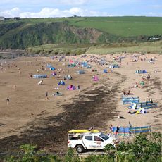
The water around the rocks requires careful timing when visiting due to strong currents, tidal shifts, and wave action. It is advisable to check tide and weather conditions beforehand to safely explore the area.
Beneath the water's surface, kelp forests grow along the reef structure and create habitats for numerous marine organisms. This hidden underwater world is not easily visible during high tide but makes the location ecologically significant.
Location: South Milton
Address: South Milton, Kingsbridge TQ7 3JY, UK
GPS coordinates: 50.25791,-3.86109
Latest update: December 6, 2025 19:09
Devon combines historical sites and natural landscapes across a region in southwest England. The area extends from moorlands in Dartmoor National Park to cliffs along the Bristol Channel and English Channel coasts. Visitors find Norman castle ruins like Totnes Castle and Okehampton Castle, Georgian manor houses such as Saltram House, medieval villages, and monastery sites like Buckland Abbey. The landscape appears in forms of granite formations, waterfalls, remote beaches, and ancient woodlands. Places include Wistman's Wood with its gnarled oak trees, the rock formations at Valley of the Rocks near Lynton, the historic fishing village of Clovelly with its steep streets, and the sandy beaches at Bantham and Mothercombe. Speke's Mill Mouth Waterfall drops directly into the sea, while Blackchurch Rock stands as a coastal formation. Gardens like RHS Garden Rosemoor display botanical collections, and industrial sites such as the water-powered Finch Foundry or the Dartmouth Steam Railway document past working environments. Beer Quarry Caves offer views into historic underground stone quarrying.
Burgh Island
3.7 km
Burgh Island Hotel
3.6 km
St Andrew's Church, South Huish
2.1 km
South Milton Ley
1.3 km
Church of All Saints
1.5 km
Church of All Saints
3.6 km
All Saints Church, South Milton
2.8 km
Bantham Beach
2.6 km
Holy Trinity
1.5 km
St Clement
1.6 km
Sloop Inn
2.3 km
Pond Cottages
3.2 km
South Milton Sands
279 m
1-10, Bantham
2.4 km
Thurlestone War Memorial
1.4 km
Rosecote Verbena And Brook Cottage
1.8 km
Inner Hope Former Lifeboat Station
1.8 km
Cross At Sx 692411
1.7 km
Bridge Cottage
1.3 km
Southdown
537 m
Boathouse At Mouth Of River Avon At Sx 664439
2.8 km
Bolt Tail Camp
1.8 km
Eliots
2.1 km
The Cabin
1.3 km
Townsend
2.2 km
Milestone, 150m S of turn to South Milton
3.7 km
Milestone, 400m S of turn to Woolston, stone alcove on clear bank
3.7 km
Coronation Boathouse and adjacent store building
2.4 kmReviews
Visited this place? Tap the stars to rate it and share your experience / photos with the community! Try now! You can cancel it anytime.
Discover hidden gems everywhere you go!
From secret cafés to breathtaking viewpoints, skip the crowded tourist spots and find places that match your style. Our app makes it easy with voice search, smart filtering, route optimization, and insider tips from travelers worldwide. Download now for the complete mobile experience.
A unique approach to discovering new places❞
— Le Figaro
All the places worth exploring❞
— France Info
A tailor-made excursion in just a few clicks❞
— 20 Minutes