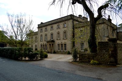
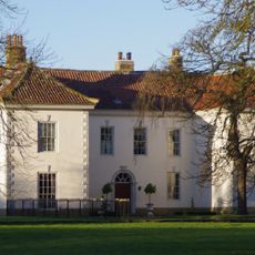
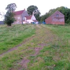
Easby Hall, Listed house in Easby, England.
Easby Hall presents a three-story central block with two-story wings constructed from coursed rubble, brick, and ashlar dressings under lead and slate roofs.
The mansion, built around 1730, came into existence after Reverend William Smith purchased the manor of Easby in 1729 and initiated its construction.
The building reflects Georgian architectural elements through its rusticated quoins, segmental fanlight, and sash windows with tripartite keystones on the north-east front.
The structure maintains its historical designation status while adapting to modern needs, with one wing divided into separate residential spaces.
The south-west garden front incorporates a porch supported by Tuscan antae, displaying Neoclassical design elements that distinguish it from other period structures.
Location: Easby
Founders: William Smith
GPS coordinates: 54.47069,-1.10850
Latest update: March 5, 2025 18:11
Roseberry Topping
3.9 km
Langbaurgh Ridge
3.8 km
Church of All Saints
3.1 km
Christ Church
3 km
Church of St Andrew
2.5 km
St Cuthbert's Church
2.7 km
Captain Cook Monument
1.8 km
Captain Cook's Schoolroom
2.6 km
The Shooting Box At Roseberry Topping
3.6 km
Great Ayton Discovery Centre
2.6 km
Ayton Hall
3.1 km
Percy Rigg Cross
4.2 km
Pair Of Boundary Stones, Approximately 2025 Metres To South Of Home Lowcross At Ngr Nz599 123
4.2 km
Meynell Hall
3 km
Ingleby Manor
3 km
Boundary Stone, Approximately 1700 Metres To South Of Home Farmhouse, Hutton Lowcross At Ngr Nz595 126
4.3 km
Boundary Stone West Of Path To Captain Cook Monument
1.9 km
Boundary Stone Approximately 400 Metres To South Of Highcliff Farmhouse At Ngr Nz606 119
4.3 km
Boundary Stone Approximately 1300 Metres To South Of Highcliff Farmhouse At Ngr Nz603 121
4.2 km
Boundary Stone, Approximately 1950 Metres To South Of Home Farmhouse Hutton Lowcross At Ngr Nz595 124
4 km
Boundary Stone, Approximately 1630 Metres To South West Of Home Farmhouse Hutton Lowcross At Ngr Nz588 129
4.3 km
Boundary Stone, Approximately 1310 Metres To South Of Highcliff Farmhouse At Ngr Nz605 121
4.3 km
Boundary Stone, Approximately 1300 Metres To South West Of Highcliff Farmhouse At Ngr Nz600 123
4.2 km
Boundary Stone East Of Path To Captain Cook Monument
2 km
Boundary Stone, Approximately 1990 Metres To South Of Home Farmhouse, Hutton Lowcross At Ngr Nz592 123
3.9 km
Boundary Stone Approximately 1940 Metres To South Of Home Farmhouse Hutton Lowcross At Ngr Nz595 124
4.1 km
Boundary Stone, Approximately 1350 Metres To South Of Highcliff Farmhouse At Ngr Nz604 120
4.2 km
Boundary Stone, Approximately 1430 Metres To South Of Highcliff Farmhouse At Ngr Nz605 119
4.2 kmReviews
Visited this place? Tap the stars to rate it and share your experience / photos with the community! Try now! You can cancel it anytime.
Discover hidden gems everywhere you go!
From secret cafés to breathtaking viewpoints, skip the crowded tourist spots and find places that match your style. Our app makes it easy with voice search, smart filtering, route optimization, and insider tips from travelers worldwide. Download now for the complete mobile experience.
A unique approach to discovering new places❞
— Le Figaro
All the places worth exploring❞
— France Info
A tailor-made excursion in just a few clicks❞
— 20 Minutes