Heronden, building in Chart Sutton, Maidstone, Kent, UK
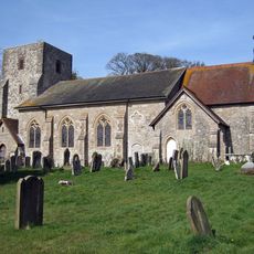
Church of St Michael
1.2 km
Mounting Block About 20 Metres West North West Of Church Of St Michael
1.2 km
Wierton Cottage
1.2 km
Ivy Cottage
396 m
Wierton Hall Farm Cottage
997 m
Barn About 56 Metres West Of East Hall
939 m
Wierton Hall
958 m
Garden Gateway About 20 Metres East Of East Hall
858 m
Barn About 70 Metres West North West Of East Hall
953 m
Old Amber Green Farmhouse
1 km
Tanyard
1.2 km
Former Granary About 15 Metres North Of Chart Place Cottages
1.3 km
Sutton Platt Cottage
1.2 km
Ladds Court
456 m
Lested Lodge
1.2 km
Rectory Farmhouse
1.2 km
Marshalls Place
980 m
Lucks Cottage
714 m
Stable To South Of Rectory Farmhouse
1.2 km
The Moorings
1.2 km
Chart Place
1.2 km
Wierton Grange
1.2 km
East Hall
887 m
House Attached To North Of Post Office Stores
1.1 km
Barn About 40 Metres South South West Of Park House Farmhouse
1.1 km
Wierton Place
1.2 km
Garden Building To The North-West Of Wierton Place
1.3 km
Chart Place Cottages
1.2 kmReviews
Visited this place? Tap the stars to rate it and share your experience / photos with the community! Try now! You can cancel it anytime.
Discover hidden gems everywhere you go!
From secret cafés to breathtaking viewpoints, skip the crowded tourist spots and find places that match your style. Our app makes it easy with voice search, smart filtering, route optimization, and insider tips from travelers worldwide. Download now for the complete mobile experience.

A unique approach to discovering new places❞
— Le Figaro
All the places worth exploring❞
— France Info
A tailor-made excursion in just a few clicks❞
— 20 Minutes