Enable Location

We need your location to show you interesting places around you

Discover nearby places

Find interesting locations and hidden gems around you

Precise directions

Get accurate directions and distances to places

Your location is never shared with other users. It's only used when you tap the location button.

Dunnicaer Hillfort

Log in to your account

Start exploring — it's free

Trusted by 63,488 travelers worldwide

Continue with Google
Continue with Apple
or

We will send you a code to connect

By continuing, you accept our Terms and Conditions and our Privacy Policy

Check your inbox

We've sent a pincode in your inbox. Please enter the code below.

Dunnicaer Hillfort
Discussion Reviews 1 Photos
3.8k Popularity

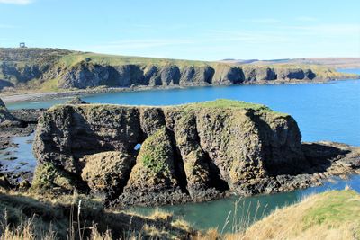
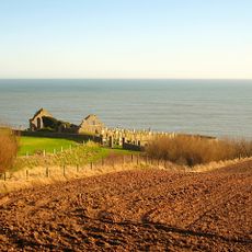
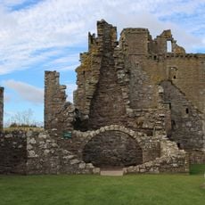
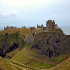
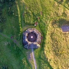
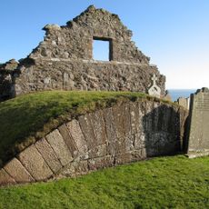
Dunnicaer Hillfort, Iron Age promontory fort near Stonehaven, Scotland.

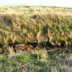
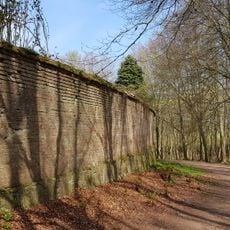
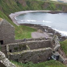
Dunnicaer Hillfort is a fortified site on a coastal headland in Aberdeenshire with stone ramparts and walls that overlook the North Sea. The location rises dramatically from the water, displaying the substantial remains of these ancient defensive structures.

Archaeological digs identified this site as the earliest known Pictish fort in Scotland, dating from the second to fourth centuries AD. Finds at the location document an important period in early Scottish history and settlement patterns.

The discovery of Pictish symbol stones in 1832 revealed important information about early communities in northeastern Scotland and their way of life. These carved stones represent how people here expressed their identity and beliefs.

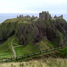
The site requires careful navigation due to coastal erosion, so visitors should check tide times before coming here. Prepare for challenging terrain and bring appropriate gear for the weather and ground conditions.

Excavations uncovered rare items such as Roman glass, samian pottery, and a lead weight that show trade connections beyond the Roman frontier. These discoveries are surprising because they prove this remote Scottish community had links with distant regions.

The community of curious travelers

AroundUs brings together thousands of curated places, local tips, and hidden gems, enriched daily by 60,000 contributors worldwide.

Start exploring
Location
GPS coordinates
56.95287,-2.19533
Latest update
December 11, 2025 18:06
Around this place
Dunnottar Castle
United Kingdom

Dunnottar Castle

803 m
Stonehaven Tolbooth
United Kingdom

Stonehaven Tolbooth

972 m
Stonehaven Open Air Pool
United Kingdom

Stonehaven Open Air Pool

2 km
Cowie Castle
United Kingdom

Cowie Castle

2.5 km
Dunnottar Parish Church
United Kingdom

Dunnottar Parish Church

2 km
Cowie Bridge
United Kingdom

Cowie Bridge

1.9 km
Glenury Viaduct
United Kingdom

Glenury Viaduct

2.7 km
Chapel of St. Mary and St. Nathalan
United Kingdom

Chapel of St. Mary and St. Nathalan

2.7 km
Town Hall, Stonehaven
United Kingdom

Town Hall, Stonehaven

1.5 km
Stonehaven, Dunnottar Avenue, Court House And Police Station
United Kingdom

Stonehaven, Dunnottar Avenue, Court House And Police Station

1.2 km
White Bridge, Stonehaven
United Kingdom

White Bridge, Stonehaven

1.4 km
Stonehaven, Arbuthnott Street, St James The Great Episcopal Church
United Kingdom

Stonehaven, Arbuthnott Street, St James The Great Episcopal Church

1.4 km
Fetteresso Church
United Kingdom

Fetteresso Church

2.2 km
Stonehaven Harbour
United Kingdom

Stonehaven Harbour

904 m
Ship Inn, 5 Shorehead, Stonehaven
United Kingdom

Ship Inn, 5 Shorehead, Stonehaven

999 m
Fetteresso Viaduct
United Kingdom

Fetteresso Viaduct

2.8 km
Dunnottar Castle, Smithy
United Kingdom

Dunnottar Castle, Smithy

812 m
Dunnottar Castle, Keep
United Kingdom

Dunnottar Castle, Keep

807 m
Dunnottar House, Walled Garden And Shell House
United Kingdom

Dunnottar House, Walled Garden And Shell House

1.7 km
Marine Hotel, Shorehead, Stonehaven
United Kingdom

Marine Hotel, Shorehead, Stonehaven

970 m
Stonehaven, Old Pier, Old Tolbooth, Sundial
United Kingdom

Stonehaven, Old Pier, Old Tolbooth, Sundial

961 m
Stonehaven and Dunnotar War Memorial
United Kingdom

Stonehaven and Dunnotar War Memorial

507 m
Stonehaven, High Street, Town House And Clock Tower
United Kingdom

Stonehaven, High Street, Town House And Clock Tower

1 km
Stonehaven, Market Square, Drinking Fountain
United Kingdom

Stonehaven, Market Square, Drinking Fountain

1.5 km
Cowie, Saint Mary's Chapel, Dead House
United Kingdom

Cowie, Saint Mary's Chapel, Dead House

2.7 km
Dunnottar Castle, Entrance Gateway And Guardrooms
United Kingdom

Dunnottar Castle, Entrance Gateway And Guardrooms

774 m
Stonehaven, 7 Carron Terrace
United Kingdom

Stonehaven, 7 Carron Terrace

1.5 km
Stonehaven, Market Square, Market Buildings
United Kingdom

Stonehaven, Market Square, Market Buildings

1.5 km
Show the full map
Reviews
Share your experience

No review yet

Discussions
Start a discussion...

No discussion yet

« Dunnicaer Hillfort - Iron Age promontory fort near Stonehaven, Scotland » is provided by Around Us (aroundus.com). Images and texts are derived from Wikimedia project under a Creative Commons license. You are allowed to copy, distribute, and modify copies of this page, under the conditions set by the license, as long as this note is clearly visible.

Discover hidden gems everywhere you go!

From secret cafés to breathtaking viewpoints, skip the crowded tourist spots and find places that match your style. Our app makes it easy with voice search, smart filtering, route optimization, and insider tips from travelers worldwide. Download now for the complete mobile experience.

Around Us App Screenshot

A unique approach to discovering new places

Le Figaro

All the places worth exploring

France Info

A tailor-made excursion in just a few clicks

20 Minutes

Around Us
Travel Guide & Maps
Download

Send to your phone

QR Code
1

Open the camera app on your mobile.

2

Point at the QR code with your camera. A notification will appear.

3

Tap the notification to open the link.