Sandomierz Basin, Geographical macroregion in southeastern Poland and western Ukraine
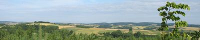
The Sandomierz Basin is a broad lowland in southeastern Poland, lying between the Carpathian range to the south and the uplands to the north. The terrain consists of gentle hills, wide river valleys, and large forest areas that spread across several regions.
During the Middle Ages, the area was almost entirely covered by dense forest, which was gradually cleared over the centuries. Today, only a few large forest complexes remain as reminders of that earlier woodland.
Wide fields and slow rivers shape daily life in the villages and small towns scattered across this broad lowland. Many communities maintain a rural way of life, where farming and small craft businesses remain central to local routines.
The area works well for walks and cycling through gentle terrain, especially in the river valleys and along forest edges. Many paths run through farming landscapes that remain accessible throughout the year.
Beneath the fields and forests lie deep ice-age deposits that reach over 2000 meters near the Carpathian edge. This hidden layer still shapes the form of river valleys and the placement of springs today.
Location: Subcarpathian Voivodeship
Location: Lesser Poland Voivodeship
Location: Lublin Voivodeship
Location: Świętokrzyskie Voivodeship
Location: Lviv Oblast
GPS coordinates: 50.31501,21.68022
Latest update: December 5, 2025 22:27
Church of the Transfiguration in Cmolas
4.7 km
Saint Bartholomew church in Majdan Królewski
8.5 km
Jewish Cemetery in Majdan Królewski
7.8 km
Category:Saint Anne church in Trzęsówka
2.2 km
Kościół parafialny w Komorowie
5.1 km
Kaplica grobowa Kozłowieckich w Majdanie Królewskim
8.4 km
Kościół Wniebowzięcia NMP w Ostrowach Tuszowskich
2.9 km
Crucifixion of Jesus wayside chapel in Majdan Królewski
8.5 km
Wayside cross in Kosowy (Popiełuszki Street)
6.3 km
Mini ZOO
4.8 km
Cmentarz w Majdanie Królewskim
8.4 km
Grave of Władysław Pogoda
5.6 km
Cmentarz wojenny z II wojny światowej w Majdanie Królewskim
8.2 km
Pateraki Nature Reserve
6.3 km
Cemetery in Kosowy
5.6 km
Mater Ecclesiae church in Zarębki
8.5 km
Pozostałości zespołu dworskiego
7.4 km
33 Siedlanka
6.7 km
Cemetery chapel in Kosowy
5.6 km
83 Wspólna Street in Hucina
6.5 km
Dzwonnica bramna w Majdanie Królewskim
8.5 km
Kaplica cmentarna w Trzęsówce
2.2 km
Church of the Transfiguration in Cmolas (new)
5 km
Sacred Heart church in Kosowy
6.1 km
Saint Anne church in Trzęsówka (new)
2.2 km
Zespół kościoła św. Anny
2.2 km
Saint Stanislaus Kostka chapel in Przyłęk
7.1 km
Wayside crucifix in Siedlanka
6.2 kmVisited this place? Tap the stars to rate it and share your experience / photos with the community! Try now! You can cancel it anytime.
Discover hidden gems everywhere you go!
From secret cafés to breathtaking viewpoints, skip the crowded tourist spots and find places that match your style. Our app makes it easy with voice search, smart filtering, route optimization, and insider tips from travelers worldwide. Download now for the complete mobile experience.
A unique approach to discovering new places❞
— Le Figaro
All the places worth exploring❞
— France Info
A tailor-made excursion in just a few clicks❞
— 20 Minutes