Enable Location

We need your location to show you interesting places around you

Discover nearby places

Find interesting locations and hidden gems around you

Precise directions

Get accurate directions and distances to places

Your location is never shared with other users. It's only used when you tap the location button.

Bexley Civic Offices

Log in to your account

Start exploring — it's free

Trusted by 62,995 travelers worldwide

Continue with Google
Continue with Apple
or

We will send you a code to connect

By continuing, you accept our Terms and Conditions and our Privacy Policy

Check your inbox

We've sent a pincode in your inbox. Please enter the code below.

Bexley Civic Offices
Discussion Reviews 1 Photos
2.1k Popularity

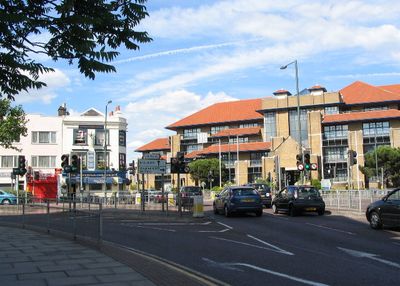
Bexley Civic Offices, Municipal offices in Watling Street, Bexleyheath, United Kingdom

The Bexley Civic Offices occupies a pagoda-style structure with multiple floors that blends modern design elements and extensive glazing. The building houses various council services including birth registrations, council tax administration, and planning applications.

The building was originally constructed in 1989 as the headquarters of Woolwich Building Society. After standing vacant from 2005, it was transformed into municipal council offices.

The building displays Mayoral Regalia in a dedicated space, reflecting the ceremonial traditions of local government. Visitors can see these symbols that represent the formal heritage of council administration.

The offices are conveniently located on Watling Street in Bexleyheath with good public transport access. Different departments are spread throughout the building, so it helps to know which service you need before arriving.

The council chamber features specialized acoustic slatted panels and a wave-designed ceiling for enhanced sound quality during official meetings. This thoughtful acoustic design allows for clear discussions even during larger assemblies.

The community of curious travelers

AroundUs brings together thousands of curated places, local tips, and hidden gems, enriched daily by 60,000 contributors worldwide.

Start exploring
GPS coordinates
51.45560,0.15370
Latest update
December 13, 2025 17:01
Around this place
Red House
United Kingdom

Red House

1.6 km
Hall Place and Gardens
United Kingdom

Hall Place and Gardens

941 m
One Bell
United Kingdom

One Bell

1.5 km
The King's Head Inn
United Kingdom

The King's Head Inn

1.6 km
Outhouse To North East Of Red House
United Kingdom

Outhouse To North East Of Red House

1.6 km
Church of St Paulinus, Crayford
United Kingdom

Church of St Paulinus, Crayford

1.5 km
Parish Church of St John the Evangelist
United Kingdom

Parish Church of St John the Evangelist

1.6 km
Christ Church Parish Church
United Kingdom

Christ Church Parish Church

894 m
Pillar Box Beside Number 48 At Junction With Parkhurst Road
United Kingdom

Pillar Box Beside Number 48 At Junction With Parkhurst Road

1.6 km
Bexley War Memorial
United Kingdom

Bexley War Memorial

1.6 km
Cineworld Cinema Bexleyheath
United Kingdom

Cineworld Cinema Bexleyheath

489 m
Crayford War Memorial
United Kingdom

Crayford War Memorial

1.3 km
Christ Church  Vicarage
United Kingdom

Christ Church Vicarage

862 m
Barn At Hall Place
United Kingdom

Barn At Hall Place

957 m
Orchard House
United Kingdom

Orchard House

619 m
Street Wall And Gateway To North Of Red House
United Kingdom

Street Wall And Gateway To North Of Red House

1.6 km
Well Head To South East Of Red House
United Kingdom

Well Head To South East Of Red House

1.6 km
The Long Shed (Part Of David Evans Limited Factory At Number 71)
United Kingdom

The Long Shed (Part Of David Evans Limited Factory At Number 71)

1.4 km
8, Upton Road
United Kingdom

8, Upton Road

1.6 km
Clock Tower At West Angle Of Market Place
United Kingdom

Clock Tower At West Angle Of Market Place

502 m
Garden Wall, Gatepiers And Gates To North Amd West Of Hall Place
United Kingdom

Garden Wall, Gatepiers And Gates To North Amd West Of Hall Place

880 m
Granary Approximately 25 Metres South South East Of Hall Place
United Kingdom

Granary Approximately 25 Metres South South East Of Hall Place

962 m
Crayford Manor House
United Kingdom

Crayford Manor House

1.3 km
The Oakwood
United Kingdom

The Oakwood

1.1 km
Milepost, Hurst Road, nr jct with Bexley High Street, by Church Hall
United Kingdom

Milepost, Hurst Road, nr jct with Bexley High Street, by Church Hall

1.6 km
High Street House
United Kingdom

High Street House

1.7 km
Lychgate to West of Parish Church of St Paulinus
United Kingdom

Lychgate to West of Parish Church of St Paulinus

1.4 km
Milestone, The Broadway, Bexley Heath, opp Zizzi restaurant and by Civic Centre
United Kingdom

Milestone, The Broadway, Bexley Heath, opp Zizzi restaurant and by Civic Centre

228 m
Show the full map
Reviews
Share your experience

No review yet

Discussions
Start a discussion...

No discussion yet

« Bexley Civic Offices - Municipal offices in Watling Street, Bexleyheath, United Kingdom » is provided by Around Us (aroundus.com). Images and texts are derived from Wikimedia project under a Creative Commons license. You are allowed to copy, distribute, and modify copies of this page, under the conditions set by the license, as long as this note is clearly visible.

Discover hidden gems everywhere you go!

From secret cafés to breathtaking viewpoints, skip the crowded tourist spots and find places that match your style. Our app makes it easy with voice search, smart filtering, route optimization, and insider tips from travelers worldwide. Download now for the complete mobile experience.

Around Us App Screenshot

A unique approach to discovering new places

Le Figaro

All the places worth exploring

France Info

A tailor-made excursion in just a few clicks

20 Minutes

Around Us
Travel Guide & Maps
Download

Send to your phone

QR Code
1

Open the camera app on your mobile.

2

Point at the QR code with your camera. A notification will appear.

3

Tap the notification to open the link.