Hall Place and Gardens

Log in to your account

AroundUs is a community-driven map of interesting places, built by curious explorers like you. It grows with every review, story, and photo you share.
Connect to save your favorite spots, contribute locations, and create personalized routes.
By continuing, you accept our Terms and Conditions and our Privacy Policy
Add to collection
Map
Suggest a change
Share

Hall Place and Gardens, Tudor mansion and museum in Bexley, England.
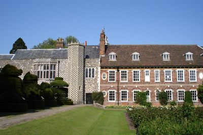
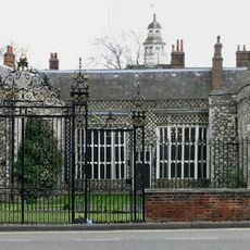
Hall Place is a Tudor mansion near London featuring stone walls, flint and timber framing, and original decorative floor tiles throughout its rooms. The site includes formal gardens with hedge topiary and a converted stable building that displays local history exhibits.

Built in 1537 by Sir John Champneys, the house marks the transition from late medieval to early Tudor design. During World War II, American military personnel used it as an intelligence center for communications work.

The name reflects its central feature, the large hall that once served as the heart of the household. Today you can see how the rooms were furnished with original and replica pieces that show how wealthy families lived in that era.

You can walk through the house rooms at your own pace or join a guided tour to learn about the architecture and furnishings. The riverside tearoom offers a comfortable spot to rest, and the gardens are accessible year-round for a walk around the grounds.

The kitchen includes a working bakehouse that shows how bread and other foods were made during Tudor times. This hands-on display gives you a real sense of daily life in the mansion.

Location: London Borough of Bexley

Address: Bourne Road, Bexley, Kent, DA5 1PQ

Website: https://hallplace.org.uk

GPS coordinates: 51.44819,0.16023

Latest update: December 8, 2025 19:40

Photos
Around this place
Show the full map
One Bell
United Kingdom

One Bell

1.2 km
Bexley Civic Offices
United Kingdom

Bexley Civic Offices

941 m
Braeburn Park
United Kingdom

Braeburn Park

891 m
The King's Head Inn
United Kingdom

The King's Head Inn

1 km
Wansunt Pit
United Kingdom

Wansunt Pit

1.4 km
Crayford Town Hall
United Kingdom

Crayford Town Hall

1.4 km
Church of St Paulinus, Crayford
United Kingdom

Church of St Paulinus, Crayford

1.3 km
Parish Church of St John the Evangelist
United Kingdom

Parish Church of St John the Evangelist

1.3 km
Parish Church of St Mary the Virgin
United Kingdom

Parish Church of St Mary the Virgin

997 m
Pillar Box Beside Number 48 At Junction With Parkhurst Road
United Kingdom

Pillar Box Beside Number 48 At Junction With Parkhurst Road

1.3 km
Bexley War Memorial
United Kingdom

Bexley War Memorial

1.2 km
Cineworld Cinema Bexleyheath
United Kingdom

Cineworld Cinema Bexleyheath

1.3 km
Crayford War Memorial
United Kingdom

Crayford War Memorial

1.4 km
Coal Duty Boundary Marker (On The South Side Of Number 1)
United Kingdom

Coal Duty Boundary Marker (On The South Side Of Number 1)

1.6 km
Orchard House
United Kingdom

Orchard House

1.5 km
Barn At Hall Place
United Kingdom

Barn At Hall Place

18 m
The Long Shed (Part Of David Evans Limited Factory At Number 71)
United Kingdom

The Long Shed (Part Of David Evans Limited Factory At Number 71)

991 m
Clock Tower At West Angle Of Market Place
United Kingdom

Clock Tower At West Angle Of Market Place

1.3 km
Cray House
United Kingdom

Cray House

1 km
High Street House
United Kingdom

High Street House

980 m
16, North Cray Road
United Kingdom

16, North Cray Road

1.1 km
Granary Approximately 25 Metres South South East Of Hall Place
United Kingdom

Granary Approximately 25 Metres South South East Of Hall Place

36 m
Lychgate to South West of Parish Church of St Mary the Virgin
United Kingdom

Lychgate to South West of Parish Church of St Mary the Virgin

1 km
Crayford Manor House
United Kingdom

Crayford Manor House

1.4 km
Lychgate to West of Parish Church of St Paulinus
United Kingdom

Lychgate to West of Parish Church of St Paulinus

1.2 km
The Oakwood
United Kingdom

The Oakwood

1.1 km
Milepost, Hurst Road, nr jct with Bexley High Street, by Church Hall
United Kingdom

Milepost, Hurst Road, nr jct with Bexley High Street, by Church Hall

1.2 km
Garden Wall, Gatepiers And Gates To North Amd West Of Hall Place
United Kingdom

Garden Wall, Gatepiers And Gates To North Amd West Of Hall Place

91 m
Show the full map
Reviews

Visited this place? Tap the stars to rate it and share your experience / photos with the community! Try now! You can cancel it anytime.

« Hall Place and Gardens - Tudor mansion and museum in Bexley, England » is provided by Around Us (aroundus.com). Images and texts are derived from Wikimedia project under a Creative Commons license. You are allowed to copy, distribute, and modify copies of this page, under the conditions set by the license, as long as this note is clearly visible.

Discover hidden gems everywhere you go!

From secret cafés to breathtaking viewpoints, skip the crowded tourist spots and find places that match your style. Our app makes it easy with voice search, smart filtering, route optimization, and insider tips from travelers worldwide. Download now for the complete mobile experience.

Around Us App Screenshot

A unique approach to discovering new places

Le Figaro

All the places worth exploring

France Info

A tailor-made excursion in just a few clicks

20 Minutes