Braeburn Park

Log in to your account

AroundUs is a community-driven map of interesting places, built by curious explorers like you. It grows with every review, story, and photo you share.
Connect to save your favorite spots, contribute locations, and create personalized routes.
Continue with Google
Continue with Apple
Continue with X
Continue with Facebook
Continue with email
By continuing, you accept our Terms and Conditions and our Privacy Policy
Create an account

Braeburn Park

Add to collection
Map
Suggest a change
Share

Braeburn Park, Nature reserve in Crayford, London, England

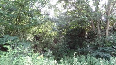
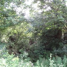
Braeburn Park is a nature reserve in Crayford that spans 22 hectares and contains grasslands, woodland areas, sandy banks, and steep cliffs. The varied terrain and different habitats create conditions where diverse plant and animal communities can coexist within this green space.

The site once supported market gardens and fruit orchards before becoming sand quarries for industrial use. When mining stopped in the 1980s, the land gradually rewilded itself and developed into the natural habitat it is today.

The space functions as a local learning hub where the London Wildlife Trust conducts hands-on education about native species and habitat protection. People from nearby neighborhoods come here to connect with nature and understand the ecosystems that thrive within their city.

The park has multiple entry points at Lower Station Road, Rochester Way, and Galloway Drive, with street parking available near each entrance. Wear sturdy shoes since the terrain is uneven and some areas can be muddy, especially after rain.

Wansunt Pit, a former sand quarry within the reserve, holds special scientific status and hosts rare invertebrate species like skipping flower beetles. This site demonstrates how industrial areas can transform into valuable habitats for specialized creatures over time.

Location: London

GPS coordinates: 51.44530,0.17220

Latest update: December 14, 2025 12:24

Photos
Around this place
Hall Place and Gardens
United Kingdom

Hall Place and Gardens

891 m
One Bell
United Kingdom

One Bell

961 m
Bexley Civic Offices
United Kingdom

Bexley Civic Offices

1.7 km
The King's Head Inn
United Kingdom

The King's Head Inn

1.6 km
Wansunt Pit
United Kingdom

Wansunt Pit

566 m
Crayford Town Hall
United Kingdom

Crayford Town Hall

793 m
Church of St Paulinus, Crayford
United Kingdom

Church of St Paulinus, Crayford

1.1 km
Parish Church of St John the Evangelist
United Kingdom

Parish Church of St John the Evangelist

2 km
Parish Church of St Mary the Virgin
United Kingdom

Parish Church of St Mary the Virgin

1.4 km
Coal Duty Boundary Marker (In The Fence To The Back Of The Garden Of Number 57 Baldwyn's Park) And Adjacent Iron Bollard
United Kingdom

Coal Duty Boundary Marker (In The Fence To The Back Of The Garden Of Number 57 Baldwyn's Park) And Adjacent Iron Bollard

1.6 km
Bexley War Memorial
United Kingdom

Bexley War Memorial

1.9 km
Coal Duty Boundary Marker (On The South Side Of Number 1)
United Kingdom

Coal Duty Boundary Marker (On The South Side Of Number 1)

1.2 km
Crayford War Memorial
United Kingdom

Crayford War Memorial

1.5 km
Barn At Hall Place
United Kingdom

Barn At Hall Place

885 m
The Long Shed (Part Of David Evans Limited Factory At Number 71)
United Kingdom

The Long Shed (Part Of David Evans Limited Factory At Number 71)

732 m
Cray House
United Kingdom

Cray House

1.5 km
Lychgate to West of Parish Church of St Paulinus
United Kingdom

Lychgate to West of Parish Church of St Paulinus

1.1 km
Milestone Opposite Nos 179 And 179A
United Kingdom

Milestone Opposite Nos 179 And 179A

1.6 km
High Street House
United Kingdom

High Street House

1.4 km
16, North Cray Road
United Kingdom

16, North Cray Road

1.5 km
Granary Approximately 25 Metres South South East Of Hall Place
United Kingdom

Granary Approximately 25 Metres South South East Of Hall Place

895 m
Crayford Manor House
United Kingdom

Crayford Manor House

1.5 km
Lychgate to South West of Parish Church of St Mary the Virgin
United Kingdom

Lychgate to South West of Parish Church of St Mary the Virgin

1.4 km
The Oakwood
United Kingdom

The Oakwood

1.1 km
Milepost, Hurst Road, nr jct with Bexley High Street, by Church Hall
United Kingdom

Milepost, Hurst Road, nr jct with Bexley High Street, by Church Hall

1.9 km
Garden Wall, Gatepiers And Gates To North Amd West Of Hall Place
United Kingdom

Garden Wall, Gatepiers And Gates To North Amd West Of Hall Place

982 m
Milestone, Old Bexley Lane, 40m E of Kent Boundary post
United Kingdom

Milestone, Old Bexley Lane, 40m E of Kent Boundary post

1.2 km
Milestone, The Broadway, Bexley Heath, opp Zizzi restaurant and by Civic Centre
United Kingdom

Milestone, The Broadway, Bexley Heath, opp Zizzi restaurant and by Civic Centre

1.9 km
Show the full map
Reviews

Visited this place? Tap the stars to rate it and share your experience / photos with the community! Try now! You can cancel it anytime.

« Braeburn Park - Nature reserve in Crayford, London, England » is provided by Around Us (aroundus.com). Images and texts are derived from Wikimedia project under a Creative Commons license. You are allowed to copy, distribute, and modify copies of this page, under the conditions set by the license, as long as this note is clearly visible.

Discover hidden gems everywhere you go!

From secret cafés to breathtaking viewpoints, skip the crowded tourist spots and find places that match your style. Our app makes it easy with voice search, smart filtering, route optimization, and insider tips from travelers worldwide. Download now for the complete mobile experience.

Around Us App Screenshot

A unique approach to discovering new places

Le Figaro

All the places worth exploring

France Info

A tailor-made excursion in just a few clicks

20 Minutes