Druridge Bay Country Park, Country park in Northumberland, United Kingdom
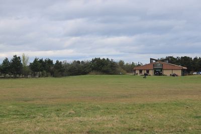
Druridge Bay Country Park is a coastal park in Northumberland featuring seven miles of sandy beach, a man-made lake, and wooded hillsides. The landscape includes grasslands and woodland areas that create a mix of open and sheltered spaces for visitors to explore.
The site was an opencast coal mine until it closed in 1983, after which the land was transformed into a public park. The abandoned mining pit was flooded to create Ladyburn Lake, which now forms the centerpiece of the landscape.
The park hosts regular Saturday parkrun events and seasonal festivals that draw locals together for outdoor activities. These gatherings have become important social occasions that shape how the community uses the space.
A visitor center, cafe, and toilets are available throughout the park, along with parking and designated areas for water sports. Most facilities are accessible during daylight hours, and clear paths make it easy to navigate the different zones.
The shoreline preserves World War II defensive structures such as anti-tank blocks and concrete pillboxes from the coast's wartime defense. These remnants remain visible as visitors walk the beach, offering a glimpse into the past without needing special access.
GPS coordinates: 55.29400,-1.57700
Latest update: December 12, 2025 17:46
Chibburn Preceptory
3.6 km
Church of St Cuthbert
4.4 km
Togston House
3.3 km
The Dock Public House
4.4 km
Amble Library
4.3 km
The Waterloo Public House
4.4 km
Parish church of St. John the Divine Chevington
2 km
Ruined Walls To East Of Roman Catholic Church Of Sacred Heart And St Cuthbert
4.4 km
The Vicarage With Outbuildings And Yard Wall
4.4 km
Hauxley Hall
3.2 km
East Cemetary Entrance Screen And Chapel Spire
4.4 km
Gate Lodge To Togston Hall
3.2 km
Hadston House Library
1.6 km
41, Queen Street
4.4 km
Gate Piers, Gates And Paddock Walls To North Of The Vicarage
4.4 km
Entrance Screen To Togston Hall
3.2 km
Farm Buildings And Attached Yard Walls To North East Of Druridge Farmhouse
4.1 km
Togston Hall (northern Area Office Of British Coal Opencast Executive)
3.1 km
Main Block Of Co Operative Society Premises
4.5 km
Dovecote 100 Metres North West Of Togston House
3.3 km
Entrance Screen And Front Wall To Togston House
3.3 km
31-39, Queen Street
4.4 km
Druridge Farmhouse
4.1 km
3 5 7, North Street
4.5 km
Garden Wall To East Of Hauxley Hall With Attached Summerhouse
3.2 km
Wall Enclosing Church Of St Cuthbert With Gates Piers And Gates
4.4 km
Low Chibburn medieval preceptory, 16th century house and World War II pillbox
3.6 km
Hauxley Farmhouse Wall And Attached Outbuildings
3.1 kmVisited this place? Tap the stars to rate it and share your experience / photos with the community! Try now! You can cancel it anytime.
Discover hidden gems everywhere you go!
From secret cafés to breathtaking viewpoints, skip the crowded tourist spots and find places that match your style. Our app makes it easy with voice search, smart filtering, route optimization, and insider tips from travelers worldwide. Download now for the complete mobile experience.
A unique approach to discovering new places❞
— Le Figaro
All the places worth exploring❞
— France Info
A tailor-made excursion in just a few clicks❞
— 20 Minutes