Marlowe House

Log in to your account

AroundUs is a community-driven map of interesting places, built by curious explorers like you. It grows with every review, story, and photo you share.
Connect to save your favorite spots, contribute locations, and create personalized routes.
Continue with Google
Continue with Apple
Continue with X
Continue with Facebook
Continue with email
By continuing, you accept our Terms and Conditions and our Privacy Policy
Create an account

Marlowe House

Add to collection
Map
Suggest a change
Share

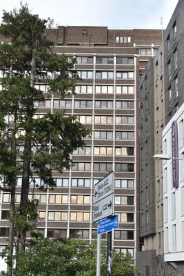
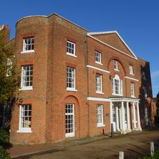
Marlowe House, Metropolitan Police building in Sidcup, United Kingdom

Marlowe House is a 17-story Metropolitan Police administration building in Sidcup that dominates the local skyline. The tower rises prominently above Station Road and stands as the tallest structure in the area.

The building was constructed during the 1960s as a major police administration center. The completion of its structure in 1966 represented an important moment in Sidcup's development.

The building houses a museum dedicated to London's police history that visitors can explore today. The exhibits show how police work and equipment have changed over the decades.

The building is located at 109 Station Road and is fully accessible with ramps and elevators for visitors with mobility needs. Modern security systems manage access while keeping the experience straightforward for all guests.

A collection of historic police vehicles opened here in 2023, showcasing how transportation changed in London police operations over the years. This display offers insight into the practical tools that equipped officers across different eras.

GPS coordinates: 51.43371,0.10187

Latest update: December 11, 2025 11:05

Photos
Around this place
Foots Cray Meadows
United Kingdom

Foots Cray Meadows

2 km
Frognal House
United Kingdom

Frognal House

1.8 km
Lamorbey Park
United Kingdom

Lamorbey Park

645 m
Parish Church of St John the Evangelist
United Kingdom

Parish Church of St John the Evangelist

1.1 km
St Lawrence church, Sidcup
United Kingdom

St Lawrence church, Sidcup

803 m
Parish Church of All Saints
United Kingdom

Parish Church of All Saints

1.9 km
St. Andrew's
United Kingdom

St. Andrew's

1.7 km
Chapel House
United Kingdom

Chapel House

2 km
Parish Church of St James
United Kingdom

Parish Church of St James

2.4 km
Manor House
United Kingdom

Manor House

1.1 km
Sidcup War Memorial
United Kingdom

Sidcup War Memorial

1.1 km
Sheffield Monument (In Churchyard Of Parish Church Of St John The Evangelist)
United Kingdom

Sheffield Monument (In Churchyard Of Parish Church Of St John The Evangelist)

1.1 km
The Seven Stars Public House
United Kingdom

The Seven Stars Public House

2.2 km
Christ Church
United Kingdom

Christ Church

842 m
Holy Trinity Church
United Kingdom

Holy Trinity Church

254 m
Stable Block To Former Foots Cray Place
United Kingdom

Stable Block To Former Foots Cray Place

1.5 km
North Cray War Memorial
United Kingdom

North Cray War Memorial

2.4 km
Five Arch Bridge
United Kingdom

Five Arch Bridge

2.2 km
10-16, Burnt Oak Lane
United Kingdom

10-16, Burnt Oak Lane

377 m
Walls Surrounding And To West And South West Of Parish Church Of St James And Gatepiers And Gates To West Of Church
United Kingdom

Walls Surrounding And To West And South West Of Parish Church Of St James And Gatepiers And Gates To West Of Church

2.3 km
1st Bexleyheath Scout Group Memorial
United Kingdom

1st Bexleyheath Scout Group Memorial

2.5 km
25 And 27, Halfway Street
United Kingdom

25 And 27, Halfway Street

318 m
Milestone On Pavement Slightly To South Of Axis Of Numbers 494
United Kingdom

Milestone On Pavement Slightly To South Of Axis Of Numbers 494

1.8 km
Lodge To Hurstmere School
United Kingdom

Lodge To Hurstmere School

991 m
Sidcup Place (Including Ha Ha To East)
United Kingdom

Sidcup Place (Including Ha Ha To East)

1.3 km
Bowling Pavillion, Foots Cray Place
United Kingdom

Bowling Pavillion, Foots Cray Place

1.6 km
Two Chest Tombs To East Side Of Parish Church Of St James
United Kingdom

Two Chest Tombs To East Side Of Parish Church Of St James

2.4 km
Tomb Of Frances Madocks To South Side Of Parish Church Of St James
United Kingdom

Tomb Of Frances Madocks To South Side Of Parish Church Of St James

2.4 km
Show the full map
Reviews

Visited this place? Tap the stars to rate it and share your experience / photos with the community! Try now! You can cancel it anytime.

« Marlowe House - Metropolitan Police building in Sidcup, United Kingdom » is provided by Around Us (aroundus.com). Images and texts are derived from Wikimedia project under a Creative Commons license. You are allowed to copy, distribute, and modify copies of this page, under the conditions set by the license, as long as this note is clearly visible.

Discover hidden gems everywhere you go!

From secret cafés to breathtaking viewpoints, skip the crowded tourist spots and find places that match your style. Our app makes it easy with voice search, smart filtering, route optimization, and insider tips from travelers worldwide. Download now for the complete mobile experience.

Around Us App Screenshot

A unique approach to discovering new places

Le Figaro

All the places worth exploring

France Info

A tailor-made excursion in just a few clicks

20 Minutes