South Park, Victorian public park in Darlington, England.
South Park is a Victorian public park in Darlington that stretches along the River Skerne with ornamental gardens, tree-lined pathways, and open green spaces. It includes a children's play area, skate park, bowling green, exercise equipment, and an aviary, plus a café for refreshments.
The park was established in 1851 on land from Poor Howdens Farm and opened in 1853 as the first Victorian public park in Northeast England. This opening represented a major shift in providing green spaces for public leisure in the region.
The Grade II listed bandstand serves as a focal point where outdoor concerts and community events bring people together throughout the year. It reflects the park's role as a social gathering place rooted in Victorian leisure traditions.
The park has multiple entrances and is easily accessible on foot with well-maintained, clearly marked pathways throughout. Different areas cater to various activities, so it helps to explore briefly to find what suits your visit.
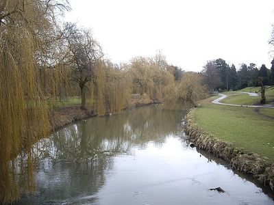
A lake with three islands sits in the northern section, surrounded by poplar trees and home to diverse bird species. This quieter area draws nature observers and forms a striking contrast to the more active zones elsewhere.
Location: Darlington
GPS coordinates: 54.51556,-1.55778
Latest update: December 9, 2025 12:21
Stockton and Darlington Railway No. 1 “Locomotion”
2.3 km
Skerne Bridge
2.2 km
Church of St Cuthbert
1.1 km
Hopetown Carriage Works
2.3 km
Blackwell Grange
683 m
Darlington Town Hall
958 m
Church of St John the Evangelist
1.2 km
Church of Holy Trinity
1.4 km
Church of St James
2.3 km
Roman Catholic Church of St Augustine
942 m
Head of Steam Darlington Railway Museum
2.3 km
Darlington Hippodrome
1.2 km
Darlington Clock Tower
1 km
Darlington Library
1.2 km
Statue of Joseph Pease
1.2 km
South African War Memorial Within St Cuthbert's Churchyard
1.1 km
Old Town Hall
994 m
The Market Building
1 km
Barclays Bank
1.1 km
Pease's House
942 m
Bridge over North Road, Darlington
2.2 km
Goods Shed East South East Of North Road Station
2.2 km
Pierremont Crescent, by No. 27
1.8 km
Allan Street, next to St James church
2.3 km
Blackwell Lane, opp. No 78
701 m
Conniscliffe Road, by Earlston House, E of jct with Linden Avenue
1 km
Carmel Road North, nr Ravensthorpe School, between Abbey Road and Cleveland Terrace
1.5 km
Cleveland Street, opp. York Street
2.3 kmVisited this place? Tap the stars to rate it and share your experience / photos with the community! Try now! You can cancel it anytime.
Discover hidden gems everywhere you go!
From secret cafés to breathtaking viewpoints, skip the crowded tourist spots and find places that match your style. Our app makes it easy with voice search, smart filtering, route optimization, and insider tips from travelers worldwide. Download now for the complete mobile experience.
A unique approach to discovering new places❞
— Le Figaro
All the places worth exploring❞
— France Info
A tailor-made excursion in just a few clicks❞
— 20 Minutes