Enable Location

We need your location to show you interesting places around you

Discover nearby places

Find interesting locations and hidden gems around you

Precise directions

Get accurate directions and distances to places

Your location is never shared with other users. It's only used when you tap the location button.

Lowes Bridge

Log in to your account

Join the adventure

Create your free account and start exploring (like 60k+ others)

We will send you a code to connect

or
Continue with Google
Continue with Apple
By continuing, you accept our Terms and Conditions and our Privacy Policy

Check your inbox

We've sent a pincode in your inbox. Please enter the code below.

Lowes Bridge

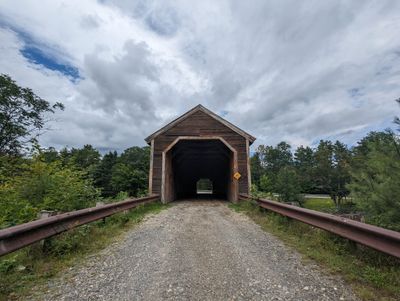
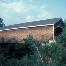
Lowes Bridge, Covered bridge in Guilford, United States

Description

Lowes Bridge is a covered wooden span crossing the Piscataquis River with design features typical of 19th-century construction. The structure displays traditional timber framing beneath a protective roof that shelters the wooden framework from weather damage.

History

The bridge was originally built in 1857 and underwent several reconstructions due to river flooding in the area. The current structure dates to 1990 and still rests on the original stone abutments from its earliest years.

Culture

The bridge stands as a reminder of Maine's traditional building practices and represents one of the few historic wooden spans that still survives in the state. It reflects how communities valued engineering solutions that could withstand the region's challenging river conditions.

Practical

The bridge sits just south of Guilford Village near Route 15 and is accessible by car. You can view and photograph it from the roadside or nearby river access points without special restrictions.

Did you know?

The 1990 reconstruction involved a remarkable engineering feat where the foundation supports were raised by several feet to protect against future flooding. The entire bridge was assembled offsite and then rolled into place, a technique rarely used for structures of this size.

Location
Inception
1857
GPS coordinates
45.17497,-69.31508
Latest update
December 14, 2025 17:42

AroundUs brings together thousands of curated places, local tips, and hidden gems, enriched daily by 60,000 contributors worldwide. Discover all places nearby (Guilford).

Around this place
Hundred-Mile Wilderness
United States of America

Hundred-Mile Wilderness

50.4 km
Gulf Hagas
United States of America

Gulf Hagas

34.4 km
Katahdin Iron Works
United States of America

Katahdin Iron Works

31.9 km
Katahdin
United States of America

Katahdin

40.6 km
Lily Bay State Park
United States of America

Lily Bay State Park

47.7 km
White Cap Mountain
United States of America

White Cap Mountain

42.6 km
Lakewood Theater
United States of America

Lakewood Theater

52.7 km
Robyville Bridge
United States of America

Robyville Bridge

37.5 km
American Woolen Company Foxcroft Mill
United States of America

American Woolen Company Foxcroft Mill

6.7 km
Saddleback Mountain
United States of America

Saddleback Mountain

39.8 km
Center Theatre
United States of America

Center Theatre

6.8 km
Hirundo Wildlife Refuge
United States of America

Hirundo Wildlife Refuge

46.6 km
Former Free Will Baptist Church
United States of America

Former Free Will Baptist Church

27.3 km
Abbott Memorial Library
United States of America

Abbott Memorial Library

16.9 km
Swedish Lutheran Church
United States of America

Swedish Lutheran Church

19.2 km
South Solon Meetinghouse
United States of America

South Solon Meetinghouse

46.7 km
Pittsfield Public Library
United States of America

Pittsfield Public Library

44.1 km
Stewart Free Library
United States of America

Stewart Free Library

28.6 km
United States of America

Chandler-Parsons Blacksmith Shop

5.5 km
Stetson Union Church
United States of America

Stetson Union Church

34.3 km
Concord Haven
United States of America

Concord Haven

49.4 km
James Sullivan Wiley House
United States of America

James Sullivan Wiley House

7.1 km
Bingham Free Meetinghouse
United States of America

Bingham Free Meetinghouse

46.6 km
Guilford Memorial Library
United States of America

Guilford Memorial Library

5.4 km
Milo Public Library
United States of America

Milo Public Library

27.5 km
Robert Carleton House
United States of America

Robert Carleton House

3.5 km
Corinth Town Hall and Corinthian Lodge No. 59, I.O.O.F.
United States of America

Corinth Town Hall and Corinthian Lodge No. 59, I.O.O.F.

30 km
Monson Engine House
United States of America

Monson Engine House

19.1 km
Show the full map
« Lowes Bridge - Covered bridge in Guilford, United States » is provided by Around Us (aroundus.com). Images and texts are derived from Wikimedia project under a Creative Commons license. You are allowed to copy, distribute, and modify copies of this page, under the conditions set by the license, as long as this note is clearly visible.

Discover hidden gems everywhere you go!

From secret cafés to breathtaking viewpoints, skip the crowded tourist spots and find places that match your style. Our app makes it easy with voice search, smart filtering, route optimization, and insider tips from travelers worldwide. Download now for the complete mobile experience.

Around Us App Screenshot

A unique approach to discovering new places

Le Figaro

All the places worth exploring

France Info

A tailor-made excursion in just a few clicks

20 Minutes

Around Us
Travel Guide & Maps
Download

Send to your phone

QR Code
1

Open the camera app on your mobile.

2

Point at the QR code with your camera. A notification will appear.

3

Tap the notification to open the link.