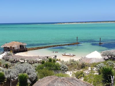
Anakao Beach, Remote beach in Atsimo-Andrefana, Madagascar.
Anakao Beach is a sandy shore along Madagascar's southern coast with calm, shallow waters that extend toward open sea. Two small uninhabited islands, Nosy Satrana and Nosy Ve, frame the bay and shape its natural character.
The location grew as a fishing port during colonial times and has maintained its maritime role ever since. Fishing boats anchored here represent generations of people who have worked these waters.
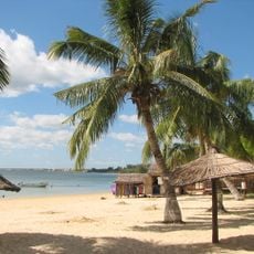
The Vezo community has built their lives around fishing here, and you can watch them launch their wooden pirogues each morning to work the waters.
Access to this beach requires boat travel from Toliara, as the southern road network makes land transport challenging. Arriving early in the day helps you see the fishing activity and local rhythms firsthand.
The nearby mangrove wetlands and surrounding vegetation host flamingo colonies, bee-eaters, and ring-tailed lemurs that visitors can spot from the beach and water. This blend of birdlife and land animals in one location is uncommon for a working fishing community.
Location: Atsimo-Andrefana
GPS coordinates: -23.65979,43.64542
Latest update: December 6, 2025 19:07
Madagascar features natural landscapes ranging from the baobab avenues near Morondava to the limestone formations of the Tsingy and coastal areas with coral reefs. The country's national parks protect tropical rainforests inhabited by lemurs, along with geological features including crater lakes and sandstone formations. The highest peaks rise in the northern mountain ranges, while the southern regions are characterized by dry landscapes. Photogenic locations include the Isalo Massif with its eroded sandstone canyons, the Masoala Peninsula with its rainforests along the Indian Ocean, and the island of Nosy Be off the northwest coast. The beaches at Ifaty and Anakao attract visitors for their reefs, while Sainte-Marie Island is known for whale watching between July and September. The Kirindy forests in the west are home to nocturnal lemurs and fossas. Historic sites include the royal hill of Ambohimanga, a UNESCO World Heritage site, and the Rova palace in Antananarivo. The geysers at Ampefy and the crater lake Tritriva showcase the volcanic history of the highlands. The red Tsingy near Sadjoavato formed through erosion of iron-rich sandstone and contrast with the gray limestone Tsingy in the west.
Avenue of the Baobabs
387.9 km
Rova of Antananarivo
663.6 km
Tsingy de Bemaraha Strict Nature Reserve
567.5 km
Isalo National Park
216.8 km
Ranomafana National Park
477 km
Iavoloha Palace
656.3 km
Mahamasina Municipal Stadium
663.6 km
Andringitra National Park
372.8 km
Andohahela National Park
335.9 km
Lemurs' Park
650.1 km
Aloalo
108.8 km
Kirindy Forest
411.9 km
Kirindy Mitea National Park
321.3 km
Berenty Reserve
308.5 km
Botanical and Zoological Garden of Tsimbazaza
662.6 km
Anja Community Reserve
385 km
Sainte Luce Reserve
379.1 km
Our Lady of La Salette Cathedral, Antsirabé
548.3 km
Andriamamovoka Falls
471.8 km
Arboretum d'Antsokay
29.7 km
FJKM Rasalama Maritiora Ambohipotsy
662.9 km
Cathédrale du Saint-Nom-de-Jésus
429.4 km
Andranomandroatra Analavory Geysers
611.7 km
Ifaty Beach
59.7 km
Cap Sainte-Marie Lighthouse
263 km
Île d’Europa
367.8 km
Mananjary Transverse Range Front Lighthouse
555.5 km
Cathedral of St. Augustine in Mananjary
553.6 kmVisited this place? Tap the stars to rate it and share your experience / photos with the community! Try now! You can cancel it anytime.
Discover hidden gems everywhere you go!
From secret cafés to breathtaking viewpoints, skip the crowded tourist spots and find places that match your style. Our app makes it easy with voice search, smart filtering, route optimization, and insider tips from travelers worldwide. Download now for the complete mobile experience.
A unique approach to discovering new places❞
— Le Figaro
All the places worth exploring❞
— France Info
A tailor-made excursion in just a few clicks❞
— 20 Minutes