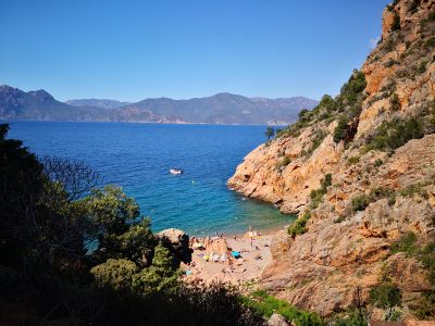
Ficaghjola Beach, Beach in Piana, France
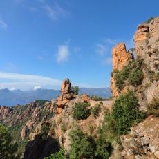
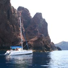
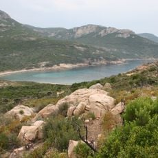
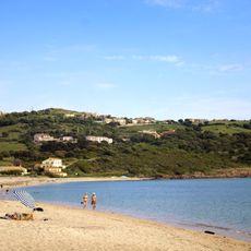
Ficaghjola Beach is a cove in Piana shaped by red granite cliffs that form a natural inlet where the Mediterranean waters sit protected. The surrounding rock faces rise steeply and narrow, creating a sheltered basin with distinct geological character.
This cove served as a harbor for fishing boats over many decades, with crews working the surrounding waters from this protected base. Old fishermen's cabins still visible here mark that long working relationship with the sea.
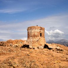
The fishermen who worked from this cove shaped how locals see their connection to the sea and the land. The red granite cliffs form part of how people here understand their natural heritage and regional identity.
Access comes via a steep and narrow road from Piana village that requires careful driving, especially during busy times. Parking is located about 800 meters from the shore, with a walking path connecting to the beach.
Trails leading from the beach push into the red rock formations around it, offering hikers different routes through the Calanques landscape. These paths let visitors explore the geology and shapes of the cliffs up close from various angles.
Location: Piana
Address: Plage de Ficaghjola, 20115 Piana, France
GPS coordinates: 42.25142,8.62677
Latest update: December 6, 2025 17:47
Corsica is a Mediterranean island with a varied landscape that ranges from rocky coastlines to white sand beaches, mountain lakes, and deep canyons. The island combines water in many forms: quiet coves with clear seas, mountain streams flowing through granite rock, and lagoons at sheltered coastal sections. These locations show the geological history of the island, with rock formations shaped by wind and water over thousands of years. Along the coast stand old watchtowers from the time when the island needed protection from attacks by sea, while inland prehistoric sites give evidence of early settlers.From the black pebble beaches on the northern coast to the long sandy beaches in the south, the island offers a range of landscapes. Some beaches lie in remote coves accessible only on foot or by boat, others are found at river mouths where fresh water meets the sea. In the mountains there are waterfalls and clear alpine lakes at elevations over 6000 feet (1800 meters). Roads through the canyons follow river courses and connect the coast to the interior, passing through narrow valleys between steep rock walls.
Calanques de Piana
8.2 km
Scandola Nature Reserve
12.7 km
Gulf of Porto: Calanche of Piana, Gulf of Girolata, Scandola Reserve
8.2 km
Torra d'Omigna
12.9 km
Torra di Girolata
10.8 km
Torra di Portu
5.7 km
Torra di Turghju
6.4 km
Torra d'Orchinu
9.4 km
Cargèse Orthodox Church
13.4 km
Arone beach
6.2 km
Église Latine de Cargèse
13.4 km
Église Saint-Jean-Baptiste de Ota
9.7 km
Église St-Pierre et Saint-Paul de Piana
1.8 km
Église Saint-François d'Osani
8.1 km
Église de l'Assomption de Piana
1.6 km
Église Saint-Jean-Baptiste de Curzo
8.6 km
Église Sant-Antoine de Padoue de Partinello
8.1 km
Ancienne église Saint-Élie de Cargèse
11.9 km
Pont génois de Pianella
11.1 km
Église Sainte-Marie de Serriera
8.8 km
Église Saint-Siméon de Marignana
7.5 km
Hôtel Les Roches Rouges de Piana
1.8 km
Pont de Zaglia
12.3 km
Chapelle funéraire de Cargèse
13 km
Église Saint-Jean-Baptiste de Lozzi
10.2 km
Piana (munisipyo)
1.6 km
Chapelle Sainte-Marie de Paomia
11.8 km
Plage de Péru
12.1 kmReviews
Visited this place? Tap the stars to rate it and share your experience / photos with the community! Try now! You can cancel it anytime.
Discover hidden gems everywhere you go!
From secret cafés to breathtaking viewpoints, skip the crowded tourist spots and find places that match your style. Our app makes it easy with voice search, smart filtering, route optimization, and insider tips from travelers worldwide. Download now for the complete mobile experience.
A unique approach to discovering new places❞
— Le Figaro
All the places worth exploring❞
— France Info
A tailor-made excursion in just a few clicks❞
— 20 Minutes