Millvale Driving Range
Location: Kgetleng River Local Municipality
GPS coordinates: -25.69011,26.91104
Latest update: October 7, 2024 20:49
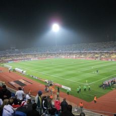
Royal Bafokeng Stadium
28 km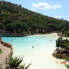
Valley of Waves
43 km
Olifantsnek Dam
36.5 km
Lindleyspoort Dam
30.8 km
Lost City Golf Course
43 km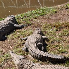
Kwena Gardens Crocodile Farm
42 km
Kosterdam
2.5 km
Olifantsnek Reservoir
36.1 km
Twyfelspoortdam
40.7 km
Lindleyspoort Reservoir
29.3 km
Rustenburg Natuurreservaat
28.2 km
Scenic viewpoint
31.3 km
Scenic viewpoint
35.6 km
Scenic viewpoint
27.8 km
Scenic viewpoint
31.3 km
Eagle Statue
31.4 km
Scenic viewpoint
31.9 km
Rustenburg Golf Club
31.9 km
Rustenburg Cross
32 km
Elephant Sculpture
35.6 km
Scenic viewpoint
31.2 km
Rustenburg Kloof
27.7 km
Elands River Battlefield
20.9 km
Koster Golfklub
20.5 km
Sun City & Lost City
42 km
Elands River Battlefield
20.4 km
Malichri Predators Rock Zoo
18.9 km
Millvale Golf Course
760 mReviews
Visited this place? Tap the stars to rate it and share your experience / photos with the community! Try now! You can cancel it anytime.
Discover hidden gems everywhere you go!
From secret cafés to breathtaking viewpoints, skip the crowded tourist spots and find places that match your style. Our app makes it easy with voice search, smart filtering, route optimization, and insider tips from travelers worldwide. Download now for the complete mobile experience.

A unique approach to discovering new places❞
— Le Figaro
All the places worth exploring❞
— France Info
A tailor-made excursion in just a few clicks❞
— 20 Minutes