Keimoes Water Mill
Location: Kai !Garib Local Municipality
GPS coordinates: -28.70972,20.97416
Latest update: October 28, 2025 10:33

Augrabies Falls
63.3 km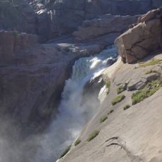
Augrabies Falls National Park
63.5 km
David & Goliath
63.5 km
Augrabies Monster
63.5 km
Ebony Tree
64.4 km
Pot Hole
64.4 km
Namaqua Fig
64.4 km
Pot Holes
63.3 km
Signs both side of river
2.2 km
Ouma Miemie
48.9 km
Ouma Miemie
48.8 km
Munincipal Blue Boards
6 km
Three advertise boards
5.8 km
Welcome to Keimoes
1.8 km
Ou Skool
4.4 km
Small signs
4.1 km
Small signs
2.6 km
Few signs
1.5 km
Scenic viewpoint
63.7 km
Scenic viewpoint
63.6 km
Scenic viewpoint
63.5 km
Scenic viewpoint
63.3 km
Scenic viewpoint
64.2 km
Scenic viewpoint
63.3 km
Scenic viewpoint
2 km
Scenic viewpoint
63.3 km
Scenic viewpoint
63.3 km
Game and Bird Hide
44.3 kmReviews
Visited this place? Tap the stars to rate it and share your experience / photos with the community! Try now! You can cancel it anytime.
Discover hidden gems everywhere you go!
From secret cafés to breathtaking viewpoints, skip the crowded tourist spots and find places that match your style. Our app makes it easy with voice search, smart filtering, route optimization, and insider tips from travelers worldwide. Download now for the complete mobile experience.

A unique approach to discovering new places❞
— Le Figaro
All the places worth exploring❞
— France Info
A tailor-made excursion in just a few clicks❞
— 20 Minutes