תעלת ההזנה
Location: מועצה אזורית תמר
GPS coordinates: 31.27555,35.39135
Latest update: November 11, 2025 13:04
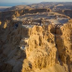
Masada
5.7 km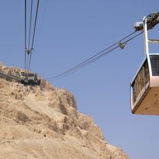
Masada cableway
5.4 km
Masada synagogue
5.9 km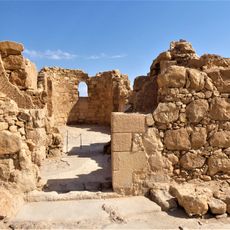
The Byzantine church
5.8 km
Gan Le'ummi Meẕada
6.1 km
Yair Ascent lookout
6.4 km
Southern Fortress
5.5 km
Lower Terrace
6 km
נקודת הפריצה
5.9 km
Scenic viewpoint
5.9 km
שער המים
5.9 km
המצודה הדרומית
5.5 km
Scenic viewpoint
4.4 km
Scenic viewpoint
2.2 km
דרגה עליונה
5.9 km
Scenic viewpoint
6.5 km
Scenic viewpoint
3.4 km
תצפית מזרחית
5.6 km
Scenic viewpoint
6.2 km
דרגה תיכונה
5.9 km
Scenic viewpoint
5.7 km
Scenic viewpoint
3.8 km
Masada arena
5.1 km
קבר הקנאים
6.1 km
השער המערבי הביזנטי
5.8 km
מפל יעלים
6.3 km
Waterfall
6.5 km
Waterfall
3.2 kmReviews
Visited this place? Tap the stars to rate it and share your experience / photos with the community! Try now! You can cancel it anytime.
Discover hidden gems everywhere you go!
From secret cafés to breathtaking viewpoints, skip the crowded tourist spots and find places that match your style. Our app makes it easy with voice search, smart filtering, route optimization, and insider tips from travelers worldwide. Download now for the complete mobile experience.

A unique approach to discovering new places❞
— Le Figaro
All the places worth exploring❞
— France Info
A tailor-made excursion in just a few clicks❞
— 20 Minutes