Thermal area
Location: Rotorua Lakes District
GPS coordinates: -38.16539,176.25372
Latest update: October 11, 2024 01:33
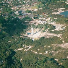
Whakarewarewa
407 m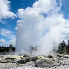
Pohutu Geyser
212 m
Rauru-me-Nuku-te-apiapi
572 m
Kusabs House
503 m
Te Awa i Manukau
321 m
Scenic viewpoint
330 m
Mud Pools
363 m
Te Puia Thermal Park
236 m
Geyser viewpoint
268 m
Scenic viewpoint
273 m
Scenic viewpoint
299 m
Scenic viewpoint
310 m
Scenic viewpoint
228 m
Red woods
226 m
Work of art, sculpture
344 m
Scenic viewpoint
351 m
Upper Whaka Outlook
232 m
Scenic viewpoint
368 m
Trig Outlook
406 m
Scenic viewpoint
216 m
Work of art, statue
411 m
Work of art, sculpture
429 m
Archaeological site
448 m
Scenic viewpoint
454 m
Tehokowhitu-A-Tu (Whakawerawera War Memorial Archway)
485 m
Scenic viewpoint
488 m
Lower Whaka Outlook
214 m
Whakarewarewa Living village
540 mReviews
Visited this place? Tap the stars to rate it and share your experience / photos with the community! Try now! You can cancel it anytime.
Discover hidden gems everywhere you go!
From secret cafés to breathtaking viewpoints, skip the crowded tourist spots and find places that match your style. Our app makes it easy with voice search, smart filtering, route optimization, and insider tips from travelers worldwide. Download now for the complete mobile experience.

A unique approach to discovering new places❞
— Le Figaro
All the places worth exploring❞
— France Info
A tailor-made excursion in just a few clicks❞
— 20 Minutes