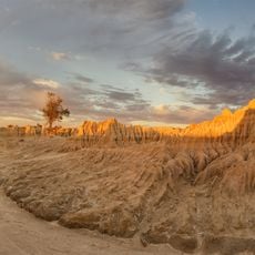
Walls Of China
Location: Mungo
Location: Balranald Shire Council
GPS coordinates: -33.74165,143.12783
Latest update: November 21, 2025 14:58
Mungo National Park
11.8 km
Willandra Lakes Region
10.3 km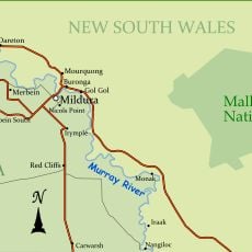
Mallee Cliffs National Park
79.4 km
PS Rodney
91.5 km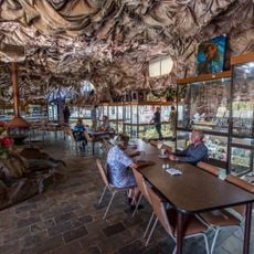
Woodsies Gem Shop
100.5 km
Hattah-Kulkyne & Murray-Kulkybe
100 km
Buronga Park
100.4 km
Wilkinson Park
96.4 km
Bilbarka Park
65.6 km
Redbank Weir
92.5 km
Billabong Pumping Station
99.9 km
Former Nichols Point Primary School Shelter Shed
100 km
Vigars Wells
5.9 km
Mungo National Park Information Centre
9.6 km
Riverside Golf Club (Victoria)
97.6 km
Varapodio Estate
99 km
Orange World
99.7 km
Trentham Estate Winery
98 km
Apex Beach
100 km
Disused Shearing Shed
9.4 km
4wd Mungo Lakes National Park Start and Finish 2wd and 4wd
11.6 km
Mungo Lunette viewing platform
67 m
Scenic viewpoint
97.1 km
Red Top Lookout
5.3 km
Old Robinvale Railway Bridge
99.2 km
Ruins
37.4 km
War Memorial
65.1 km
Memorial, war memorial
99.3 kmReviews
Visited this place? Tap the stars to rate it and share your experience / photos with the community! Try now! You can cancel it anytime.
Discover hidden gems everywhere you go!
From secret cafés to breathtaking viewpoints, skip the crowded tourist spots and find places that match your style. Our app makes it easy with voice search, smart filtering, route optimization, and insider tips from travelers worldwide. Download now for the complete mobile experience.

A unique approach to discovering new places❞
— Le Figaro
All the places worth exploring❞
— France Info
A tailor-made excursion in just a few clicks❞
— 20 Minutes