Grass Trees
Location: Coolah
Location: Warrumbungle Shire Council
Operator: NSW NPWS
GPS coordinates: -31.73313,150.02080
Latest update: October 11, 2024 01:35
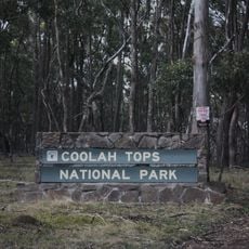
Coolah Tops National Park
8 km
Bowen Oval
30.1 km
Bottom Weir
18 km
Bryan Egan Weir
18 km
Norfolk Falls
1.8 km
Cunningham and Leichhardt
10.6 km
Scenic viewpoint
1.8 km
Bald Hill's Falls
2.7 km
Rocky Creek Falls
3.2 km
Waterfall
3.2 km
Scenic viewpoint
3.2 km
The Bundella Lookout
4.1 km
Lava Cave
4.2 km
The Pinnacle Lookout
4.4 km
Talbragar River Falls
7.2 km
Scenic viewpoint
7.2 km
Memorial, commemorative plaque
1.6 km
Scenic viewpoint
1.8 km
Pandora Pass
10.8 km
Cunninghams Camp Monument
11.8 km
Coxs Creek Falls
1.2 km
Waterfall
1.2 km
Breeza Lookout
18.9 km
Shepherd's Peak
20 km
Scenic viewpoint
27.4 km
Black Stump Rest Area
29.8 km
Memorial
29.8 km
Cox's Creek Sawmill
694 mReviews
Visited this place? Tap the stars to rate it and share your experience / photos with the community! Try now! You can cancel it anytime.
Discover hidden gems everywhere you go!
From secret cafés to breathtaking viewpoints, skip the crowded tourist spots and find places that match your style. Our app makes it easy with voice search, smart filtering, route optimization, and insider tips from travelers worldwide. Download now for the complete mobile experience.

A unique approach to discovering new places❞
— Le Figaro
All the places worth exploring❞
— France Info
A tailor-made excursion in just a few clicks❞
— 20 Minutes