Aircraft Drop Tank
Location: Eromanga
Location: Quilpie Shire
GPS coordinates: -26.27539,143.21381
Latest update: November 10, 2025 10:46
Quandamooka people
139.3 km
Hell Hole Gorge National Park
126.4 km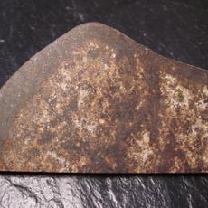
Tenham meteorite
65.9 km
Welford Homestead
144.2 km
Old Post Office - Private Residence
144.4 km
The Hut - Elliots - Adavale Veterans Retreat
144.3 km
Hell Hole Waterhole
125.4 km
Spencers Waterhole
127.1 km
Flood Levels - Point of Interest
111.7 km
Old Court House
110.1 km
Sandos Sandhill (Photo-Op)
121.4 km
Desert Waterhole
125.4 km
Sand dune
128.2 km
The Old Church - Private Residence
144.7 km
Quilpie Golf Course
107.7 km
Opal Altar
111.9 km
Quilpie Star Gazing Site
124.9 km
VH-KTE Beechcraft Aircraft Crash Memorial
144.4 km
Great Artesian Basin
111.3 km
Lyn Barnes Outback Art - Eagle Gallery
111.1 km
Sauropod and her two babies
44.5 km
Lake Houdraman
114.3 km
Baldy Top Lookout
108.7 km
Quilpie Star Gazing Site
124.9 km
Bob Young Memorial Park
111.8 km
Angus Steele Chapman
85.6 km
Michael Magee's shanty site
144.2 km
VH-KTE Crash Memorial
144.4 kmReviews
Visited this place? Tap the stars to rate it and share your experience / photos with the community! Try now! You can cancel it anytime.
Discover hidden gems everywhere you go!
From secret cafés to breathtaking viewpoints, skip the crowded tourist spots and find places that match your style. Our app makes it easy with voice search, smart filtering, route optimization, and insider tips from travelers worldwide. Download now for the complete mobile experience.

A unique approach to discovering new places❞
— Le Figaro
All the places worth exploring❞
— France Info
A tailor-made excursion in just a few clicks❞
— 20 Minutes