Sand dune
Location: Jundah
Location: Barcoo Shire
GPS coordinates: -25.12452,143.15962
Latest update: November 1, 2025 01:13
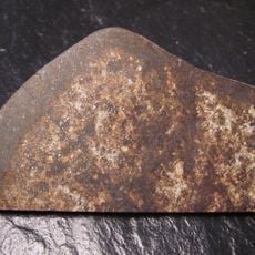
Tenham meteorite
71 km
Idalia National Park
155 km
Welford National Park
36.8 km
Welford Homestead
23.9 km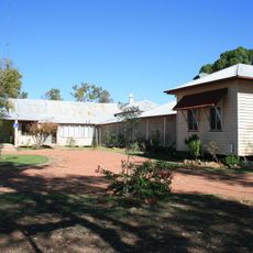
Old Isisford District Hospital
161.2 km
XXXX Hill - 44 Gal Drum on a Stick
86.9 km
Stonehenge Address Book
87.4 km
Spencers Waterhole
113.8 km
Flood Levels - Point of Interest
51.8 km
Old Court House
60.6 km
Hole in Mt Henderson
138.8 km
Sandos Sandhill (Photo-Op)
67 km
J C Hotel Ruins
130 km
Native Well
54.6 km
Native Well
133.9 km
Aircraft Drop Tank
128.2 km
Hell Hole Waterhole
113.3 km
Mount Slowcombe Lookout
95.9 km
Scenic viewpoint
60.8 km
Emmet Pocket Lookout
157.7 km
Scenic viewpoint
86.9 km
Historic Site of Tocal Hotel
139.9 km
Major Mitchell Marker
154.1 km
Barcoo War Memorial
34.2 km
Monument
49 km
ANZAC
96 km
Monument
96.5 km
Michael Magee's shanty site
51.5 kmReviews
Visited this place? Tap the stars to rate it and share your experience / photos with the community! Try now! You can cancel it anytime.
Discover hidden gems everywhere you go!
From secret cafés to breathtaking viewpoints, skip the crowded tourist spots and find places that match your style. Our app makes it easy with voice search, smart filtering, route optimization, and insider tips from travelers worldwide. Download now for the complete mobile experience.

A unique approach to discovering new places❞
— Le Figaro
All the places worth exploring❞
— France Info
A tailor-made excursion in just a few clicks❞
— 20 Minutes