The Arch
Location: Hill End
Location: Bathurst Regional Council
GPS coordinates: -33.01616,149.41613
Latest update: November 16, 2025 03:42

Nubrygyn Inn and Cemetery
36.1 km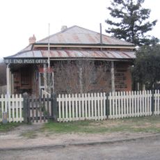
Hill End Historic Site
1.9 km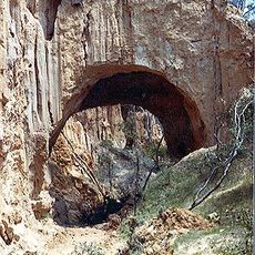
Golden Gully and Archway
22 m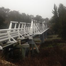
Wallaby Rocks Bridge
22.8 km
Gold Mining Water Race, Windeyer
28.2 km
Quartz Roasting Pits Complex
6.6 km
Sofala Park
26.8 km
History Hill Museum
1.7 km
Canobolas Regional Park
34.7 km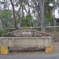
Horse trough
1.4 km
Scenic viewpoint
3.5 km
Scenic viewpoint
30.6 km
Scenic Dune Buggies
4.3 km
Scenic viewpoint
8.1 km
Wattle Flat Golf Course
32.4 km
Kissing Point
3.4 km
Bald Hill
2.5 km
Beaufoy Merlin Lookout
3.9 km
Scenic viewpoint
26.7 km
Bald Hill Mine
2.5 km
Monument
23.6 km
Archaeological site
23.6 km
Roasting pits
6.6 km
Battery
6.6 km
Memorial
35 km
Bells Falls
25.3 km
Kittys Falls
3.3 km
Tambaroora Waterfall
8.7 kmReviews
Visited this place? Tap the stars to rate it and share your experience / photos with the community! Try now! You can cancel it anytime.
Discover hidden gems everywhere you go!
From secret cafés to breathtaking viewpoints, skip the crowded tourist spots and find places that match your style. Our app makes it easy with voice search, smart filtering, route optimization, and insider tips from travelers worldwide. Download now for the complete mobile experience.

A unique approach to discovering new places❞
— Le Figaro
All the places worth exploring❞
— France Info
A tailor-made excursion in just a few clicks❞
— 20 Minutes