Lavoir du rivier
Location: Nantoin
Location: Porte-des-Bonnevaux
GPS coordinates: 45.43919,5.27280
Latest update: November 12, 2025 02:02
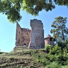
Château de Bocsozel
3.4 km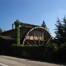
Moulin de Nantoin
597 m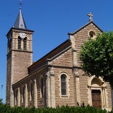
Église Saint-Nicolas de Mottier
3.8 km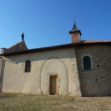
Chapelle Notre-Dame du Mont in Gillonnay
4.5 km
Mont Avalon
4.6 km
Point de vue sur Moulin
556 m
Table d'orientation
4.4 km
Catholic church building, wayside cross, Christianity
2.9 km
Catholic church building, wayside cross, Christianity
4.4 km
La Madone
4.6 km
Statue, Work of art
4.5 km
Statue, Work of art
4.5 km
Wayside cross
3.5 km
Catholic church building, wayside cross, Christianity
2 km
Moulin à Blé 19° siècle
571 m
Catholic church building, wayside shrine, Christianity
2.5 km
Catholic church building, wayside cross, Christianity
4.6 km
Wayside cross, Christianity, Catholic church building
4.5 km
Lavoir de bonnafond
662 m
Catholic church building, wayside cross, Christianity
4.3 km
Wayside cross, Christianity, Catholic church building
4.2 km
Catholic church building, wayside cross, Christianity
4.4 km
Catholic church building, wayside cross, Christianity
4.4 km
Catholic church building, wayside cross, Christianity
761 m
Catholic church building, wayside cross, Christianity
3.6 km
Wayside cross
2.7 km
Wayside cross
4.7 km
Wayside cross
4.7 kmReviews
Visited this place? Tap the stars to rate it and share your experience / photos with the community! Try now! You can cancel it anytime.
Discover hidden gems everywhere you go!
From secret cafés to breathtaking viewpoints, skip the crowded tourist spots and find places that match your style. Our app makes it easy with voice search, smart filtering, route optimization, and insider tips from travelers worldwide. Download now for the complete mobile experience.

A unique approach to discovering new places❞
— Le Figaro
All the places worth exploring❞
— France Info
A tailor-made excursion in just a few clicks❞
— 20 Minutes