Stone Map of Georgia with a Flag in the centre
Location: ყაზბეგის მუნიციპალიტეტი
GPS coordinates: 42.60245,44.39921
Latest update: November 18, 2025 09:20
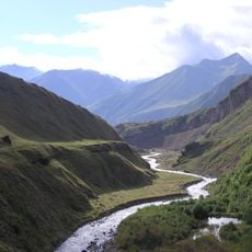
Truso valley
7.5 km
Jvari Pass Travertine Natural Monument
9.9 km
Truso Travertines Natural Monument
3.2 km
Laghztsiti
8.7 km
Keterisi Mineral Vaucluse
676 m
Mq'invari Sherkhot'a
8.2 km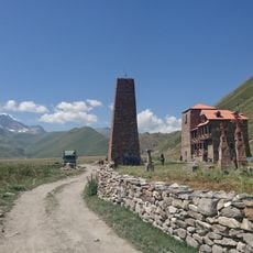
Კოშკები
946 m
Კოშკების კომპლექსი
946 m
Სამების ქვემო ეკლესია
3.5 km
Ზაქაგორის ნასოფლარი
2.3 km
Ეკლესია
6.8 km
Ზაკაგორის კოშკების კომპლექსი გალავნით
2.3 km
Zakagori Fortress
2.3 km
Cliff with waterfalls
4.6 km
Truso Valley
5.9 km
Scenic viewpoint
2.7 km
Truso valley
2.5 km
Scenic viewpoint
2.8 km
Scenic viewpoint
2.6 km
Calcareous sinter
9.8 km
Scenic viewpoint
2.4 km
House of prayer, place of worship, wayside shrine, Christianity
2.7 km
Christianity, tourist attraction, house of prayer, place of worship, wayside shrine
3.2 km
Obelisk, memorial
5.9 km
Waterfall
6.7 km
Waterfall
9.7 km
Ჩანჩქერი
7 km
Ჭანჭ
7 kmReviews
Visited this place? Tap the stars to rate it and share your experience / photos with the community! Try now! You can cancel it anytime.
Discover hidden gems everywhere you go!
From secret cafés to breathtaking viewpoints, skip the crowded tourist spots and find places that match your style. Our app makes it easy with voice search, smart filtering, route optimization, and insider tips from travelers worldwide. Download now for the complete mobile experience.

A unique approach to discovering new places❞
— Le Figaro
All the places worth exploring❞
— France Info
A tailor-made excursion in just a few clicks❞
— 20 Minutes